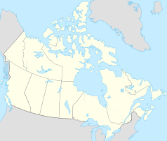
Ross River (Yukon)
| Ross River | ||
|---|---|---|
| Location in Yukon | ||
|
|
||
| State : |
|
|
| Territory : | Yukon | |
| Coordinates : | 61 ° 35 ′ N , 132 ° 16 ′ W | |
| Residents : | 313 (as of 2006) | |
Ross River is a place in the Canadian Yukon , which is located at the confluence of the Ross River and Pelly River , or on Canol Road .
In 2006 it had 313 residents, 270 of whom belonged to the Ross River First Nation .
It is accessible via the Robert Campbell Highway and Ross River Airport , which has flights to Whitehorse and Watson Lake .
In the village is the Ross River Dena Council , which represents the tribe of the Ross River First Nation. These are among the Kaska people who also live in Watson Lake and in some places in northern British Columbia . The number of recognized tribal members is given as a total of 484 (January 2009).
history
At the confluence of the Ross and Pelly Rivers there was a Kaska summer camp that was used over and over again for several millennia.
In 1901, Tom Smith established a trading post he named Smiths Landing . The following winter, 15 Indian families spent the winter nearby. In 1903, however, a rival post arose on the opposite south bank of the Pelly, where mainly Kaska settled. But other, nomadic groups from the Mackenzie River area tied the post to the northern trade network. Around 1914, up to a thousand Indians gathered around the two trading posts in the summer, but the Spanish flu decimated their numbers and they left the region.
Road construction in connection with the Second World War, especially the Alaska Highway and Canol Road with the associated pipeline, brought several thousand road construction workers to the region at short notice. But from 1946 to 1958 Canol Road was closed again. The fall in fur prices around 1950 also led to the trading posts being closed. 1952 Ross River was declared a tribal village (band village). The last trading post remained here. Because the road construction had shifted the economic center to the south side of the Pelly, the government exerted pressure to relocate the Indians there. They gave up their old village in the mid-1960s and moved to Ross River.
The Faro mines again brought large numbers of workers to the region. Ross River residents Arthur John, Jack Ladue, Robert, and Joe Etzel had led Al Kulan to Vangorda Creek, where he made his first claim . However, the First Nation did not benefit from the boom that his company triggered in the region.
It was not until 1975 that the place was given a radio reception facility, and one for television reception in 1979.
In 2003, the Ross River Dena joined forces with six other First Nations to form the Alaska Highway Pipeline Group to counter the threats posed by the US pipeline project. In previous years, they had already opposed uses of their traditional area that had not been agreed with them, such as logging. Despite recognition as an "Indian tribe" (band), the Supreme Court refused in 2002 to grant them a reservation .
Web links
Remarks
- ^ Statistics Canada
- ↑ According to the Department of Indian Affairs and Northern Development , Ross River ( Memento of the original dated February 16, 2009 in the Internet Archive ) Info: The archive link was inserted automatically and has not yet been checked. Please check the original and archive link according to the instructions and then remove this notice.
