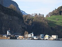
Snot hole

Rotzloch (also Rozloch ) is a village in the municipality of Ennetmoos and an industrial area of Stansstad in the canton of Nidwalden in Switzerland .
geography
The Rotzloch is a small patch of shore ( 437 m above sea level ) between the Rotzberg ( 672 m above sea level ) with the Rotzberg castle ruins and the Alpnachersee ( 436 m above sea level ). The village and the industrial area are separated by the Mehlbach, which also forms the municipal boundary between Ennetmoos and Stansstad right into the middle of the Rotzschlucht gorge. Originally the Mehlbach, which plunged down the Rotzschlucht, created a delta here.
The stream also supplied the energy that was used by various companies for their production over the course of more than 400 years and thus made the snot hole an industrial location.
history
Rotz- in the name Rotzloch is Gallo-Roman origin.
The snot hole played a historical role when the local population rose up against French rule during the days of horror in Nidwalden in 1798 . The French troops under General Schauenburg advanced among other things through the Rotzschlucht towards Stans. After the advance was initially stopped by taking advantage of the area, the Nidwalden had to bow to the superiority of the Allweg part of the municipality of Ennetmoos on September 9th.
From the 1830s onwards, liberal, federally-minded personalities who, as a snot-hole society, had an impact on public life, met in the snot hole .
In the second half of the 19th century, the rock of the Rotzberg was discovered as a source of raw materials. Since then, the village has been dominated by the Steinag Rozloch AG plants, which process stone here.
Due to its location directly on Lake Lucerne , the village also has a pier for the shipping company of Lake Lucerne .
Rotzschlucht and Mehlbach
The around 400 m long Rotzschlucht is located at the lowest point between the Rotzberg and the Mueterschwanderberg. The Mehlbach flowing in the gorge bottom has eaten its way into the mountains and formed a strange landscape. Its steep gradient was used for economic development early on.
The Rotzloch was the first commercial and industrial center and for a long time an exception in Nidwalden. The energy of the Mehlbach has been used since 1597 for a mill and the Rotzloch paper factory founded at that time. By 1626 a bath house (sulfur spring ), an oil trot , a powder mill , a sawmill, a tannery and an iron smelter were built. The Rotzloch Portland cement factory was established in 1893 .
During the Second World War , the Oskar Reinhart Collection , the Gottfried Keller Foundation and other larger art museums used a tunnel in the former Rotzloch quarry as a safe storage space for their works of art.
In 1975, the first cheese ripening store in Switzerland was set up in the Rotzschlucht, where a 100 m long and 40 m high rock cellar is used as a cheese cellar for ripening. The peculiarity of this natural ripening is an average annual temperature of 8-10 degrees Celsius and a humidity of around 90%. Since 2002 the rock storage facility has provided space for around 800 tons of cheese.
The economic development in the Rotzschlucht is documented by numerous buildings: the ruins of the old mill are evidence of early industrialization, tunnels show the beginnings of mining, the sulfur spring stands for a tourist era and the hydropower plants consist of components from different decades.
literature
- Karl Flüeler: Snot hole. Industry for 400 years. A contribution to the economic history of Nidwalden with genealogical notes concerning the families Ryser, Achermann, Schnieper, Stiltzy, Zumbüel, Blättler, and a report by Adalbert Vokinger on the development of the Rotzloch industrial companies over the past 50 years. With the collaboration of Adalbert Vokinger. Historical Association Nidwalden, Stans 1977
- Josef Flüeler-Martinez: Rotzloch / Rozloch: Birthplace of the Nidwalden industry . Stansstad 2008, ISBN 978-3-906997-47-6 .
Web links
- Fabian Hodel: Snot hole. In: Historical Lexicon of Switzerland .
- Steinag Rozloch AG website with photos
- Canton of Nidwalden: Factory work in Nidwalden
Coordinates: 46 ° 58 ' N , 8 ° 20' E ; CH1903: 667 879 / 201963
Individual evidence
- ↑ Albert Hug, Viktor Weibel: Nidwalden place and field names. Vol. 1, Historical Association Nidwalden, Stans 2000, Sp. 281 (sv Rotzberg )
- ↑ GMS-Reisen: Lucerne / Pilatus key area (PDF)
- ^ «Concern for the protection of works of art» - The Swiss cultural property repatriation in the Second World War . In: Neue Zürcher Zeitung, December 10, 2001


