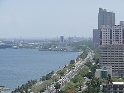
Roxas Boulevard
| Roxas Boulevard Radial Road 1
|
|
|---|---|
| Street in Manila, Pasay City, Parañaque City | |
| Basic data | |
| place | Manila, Pasay City, Parañaque City |
| Hist. Names | Dewey Boulevard |
| Connecting roads | Ninoy Aquino International Airport Road in Parañaque City |
| Cross streets |
Ermita :
Malates :
|
| Technical specifications | |
| Street length | 7.6 km |
The Roxas Boulevard (former name: Dewey Boulevard ) is a boulevard in Metro Manila . The eight-lane main artery connects the center of Manila with Pasay City and Parañaque City . It is one of the most important connections in the road network of the metropolitan area around the Philippine capital and is designated as Radial Road 1 . The previous name in honor of the American Admiral George Dewey , who defeated the Spanish Navy in the Battle of Manila Bay in 1898 , was changed in the 1960s in honor of Manuel Roxas , the fifth President of the Philippines in Roxas Boulevard. Roxas Boulevard runs along the shoreline of Manila Bay and is known for its sunset views. It developed into the trademark of Filipino tourism, to which the yacht club , several hotels , upscale restaurants and parks have contributed. The curved road leads from north to south. The northern end point is at Rizal Park in Manila. In the south, the road ends in Parañaque City at the intersection with Ninoy Aquino International Airport Road (NAIA Road for short). The Manila-Cavite Expressway begins south of it .
Buildings and facilities
Parks
CCP complex
- Cultural Center of the Philippines
- Folk Arts Theater
- Manila Film Center
- Star City
- Philippine International Convention Center (CCP Complex)
- World Trade Center Metro Manila (CCP Zomplex)
- ASEAN Garden
- Boom on boom
Government building
- Bangko Sentral ng Pilipinas (Central Bank of the Philippines)
- Ministry of Foreign Affairs
- Ministry of Finance
- Philippine Navy
- Senate of the Philippines (GSIS Building)
- Vice President's Office ( Coconut Palace )
Embassies
Shopping centers
Museums
- Metropolitan Museum of Manila
- Museo Pambata (Central Bank of the Philippines)
- Bangko Sentral ng Pilipinas (Central Bank of the Philippines) Money Museum
Hotels
- Manila Hotel
- Sofitel Plaza Hotel (CCP Complex)
- Heritage Hotel Manila
- Midas Hotel & Casino (formerly: Hyatt Regency Manila)
Yacht club
Coordinates: 14 ° 34 ′ 5 ″ N , 120 ° 59 ′ 0 ″ E

