Rucava
| Rucava ( German : Rutzau) | ||
|---|---|---|
 Help on coat of arms |
|
|
| Basic data | ||
| State : |
|
|
| Landscape: | Courland ( Latvian : Kurzeme ) | |
| Administrative district : | Rucavas novads | |
| Coordinates : | 56 ° 10 ' N , 21 ° 10' E | |
| Residents : | 550 (Jun 3, 2015) | |
| Area : | ||
| Population density : | ||
| Height : | 12 m | |
| Website: | www.rucava.lv | |
| Post Code: | ||
| ISO code: | ||
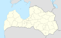
Rucava (German Rutzau ) is the southwesternmost town in Latvia on the Baltic Sea and the Lithuanian border.
history
The place was first mentioned in 1253 in writing, as to the field of treatments between the Teutonic Order and the Bishop of Kurland was divided. In the 17th century, Gut Rutzau was the crown property of the Dukes of Courland . The village arose at the estate's post office, where the road from Libau to Memel ran .
Rucavas novads
This was formed in 2009 from the municipalities of Rucava and Dunika. In 2010, 1998 residents were registered.
literature
- Rutzau. In: Alexander Duncker: The rural residences, castles and residences of the knightly landowners in the Prussian monarchy. 16 volumes, Berlin 1857–1884. (Article with color chart online as PDF document )
- Hans Feldmann , Heinz von zur Mühlen (ed.): Baltic historical local dictionary, part 2: Latvia (southern Livonia and Courland). Böhlau, Cologne 1990, ISBN 3-412-06889-6 , p. 532.
- Astrīda Iltnere (ed.): Latvijas Pagasti, Enciklopēdija. Preses Nams, Riga 2002, ISBN 9984-00-436-8 .
Footnotes
- ↑ Hans Feldmann, Heinz von zur Mühlen (ed.): Baltic historical local dictionary, part 2: Latvia (southern Livland and Courland). Böhlau, Cologne 1990, p. 532.
