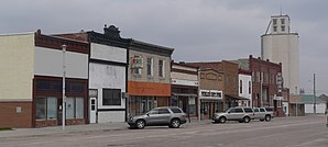
Rushville, Nebraska
| Rushville | ||
|---|---|---|
 |
||
| Location in Nebraska | ||
|
|
||
| Basic data | ||
| Foundation : | 1885 | |
| State : | United States | |
| State : | Nebraska | |
| County : | Sheridan County, Nebraska | |
| Coordinates : | 42 ° 43 ′ N , 102 ° 28 ′ W | |
| Time zone : | Mountain ( UTC − 7 / −6 ) | |
| Residents : | 890 (as of 2010) | |
| Population density : | 298.7 inhabitants per km 2 | |
| Area : | 2.98 km 2 (approx. 1 mi 2 ) of which 2.98 km 2 (approx. 1 mi 2 ) is land |
|
| Postal code : | 69360 | |
| Area code : | +1 308 | |
| FIPS : | 31-42775 | |
| GNIS ID : | 0832788 | |
Rushville is a city in Sheridan County , Nebraska . In 2010 there were 890 residents in Rushville. The city is the county seat of Sheridan County.
history
Rushville was founded in October 1885. Its name is derived from Rush Creek. In the Lakota language , Rushville is called "the place where things are transported".
population
In 2010, of the 890 inhabitants, 73.8 percent were white, 0.6 percent African American, 21.9 percent Native American, 0.1 percent Asian, 0.6 percent from other races and 3.0 percent from two or more races. 6.1 percent of the population were Hispanic or Latino of any origin.
Web links
Commons : Rushville, Nebraska - collection of pictures, videos, and audio files
