Sacca Fisola
| Sacca Fisola | ||
|---|---|---|
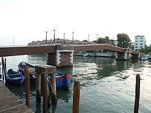
| View of Sacca Fisola | ||
| Waters | Venice lagoon | |
| Geographical location | 45 ° 25 ′ 41 ″ N , 12 ° 18 ′ 52 ″ E | |
|
|
||
| length | 690 m | |
| width | 415 m | |
| surface | 18.07 hectares | |
| Highest elevation | 2 m | |
| Residents | 1480 (2008) 8190 inhabitants / km² |
|
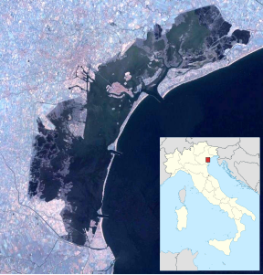
| Location of Sacca Fisola on the western edge of the Giudecca | ||
The Sacca Fisola is created by landfills in 1953 artificial island in the Venetian Lagoon . On August 29, 2009, exactly 1,480 residents were counted, in 2016 there were 1,452.
Expansion, location
The 18-hectare island belongs to the Dorsoduro district of the historic center and is used almost exclusively as a residential area. Most of the buildings were built between 1958 and 1968. Sacca Fisola is the most westerly of the islands that make up the Giudecca , after the island of Sacca San Biagio , which is the site of a waste incineration plant and to which a narrow wooden bridge leads . A footbridge also leads east from Sacca Fisola over the 50 to 70 meter wide and 330 meter long Canale dei Lavraneri to Campiello Friuli on the Giudecca island (group). Sacca Fisola is connected to the public shipping traffic by flat boats called vaporetti . One of the four stops is located on the island, namely Sacca Fisola , which is connected to Palanca , Redentore and Zitelle to the east .
history
On the unplanned island, affordable living space for the workers was to be created in the city of Venice, which was still densely populated at the time. However, the island was not created again as a result of the construction work; instead, due to waste and building rubble, an island had long since emerged there in an unplanned manner that only had to be structurally secured and provided with an infrastructure. It was already possible to cultivate the land at the end of the 19th century. There was also a small industrial plant, later a transformer.
In 1942, the Istituto fascista autonomo per le case popolari della Provincia di Venezia developed plans to build houses there, but they never came to fruition. With modern technology and materials, the city of Venice should find its continuation at this point.
In 1956, the plans from 1942 were resumed, but wanted to prevent a mere dormitory town from being built there. Social centers, a cinema, a kind of vocational school and sports facilities were planned, but these plans were abandoned early on. Between 1958 and 1968, only residential buildings were built, led by a group led by the then “star architect” Giuseppe Samonà. The construction is in no way based on the Venetian core city, but is regular, the mostly three to five-story houses are isolated, often organized around courtyards. There was also no resemblance to the other islands of the Giudecca, which have a dense building front to the north, open to the lagoon to the south and are interspersed with gardens and park-like facilities. Only the main square is in the middle of the island, the Campo della chiesa. There are also shops, a bar and a kindergarten. Of the nine shops at the time, six were under the only arcades on the island, which were also referred to as "rudimentary in their expression". The space, however, was hardly used. The two bars next to the vaporetto stop developed, just as unplanned, as the second essential communication point on the island.
By 1991, 35% of the island was undeveloped, which creates numerous unused areas that give the district something disorganized, numerous walls have been erected for no apparent reason, rows of houses look like never before. Due to the fact that no jobs were created on the island, practically the entire working population leaves the island in the morning to return home in the evening, also correspondingly outdated urban concepts from the post-war decades. Most of them go to Marghera , but some also go to the tourist businesses in the old town.
There are three small islands south of the island, on one of which household waste is collected and dumped.
On the island is the church of San Gerardo Segredo . Sacca Fisola and Sacca San Biagio make up the territory of their parish.
Web links
See also
literature
- Nicola Piacentini: Identità, futuro, tradizione: Sacca Fisola 2.0 , Tesi di Laurea Magistrale in Architettura per il Nuovo e l'Antico, Venice 2017.
- Aldo Navoni: Sacca Fisola , Venice 2014 (photo book).
- Isabela Tiñana Díaz: Urban Completion of Sacca Fisola and Sacca San Biagio in Venice , University of Notre Dame, 2016.
supporting documents
- ↑ Ma quanti sono i veneziani? , in: Metropolitano.it, November 2, 2016.
- ↑ This and the following from: Kaj Noschis: The affective meaning of neighborhood , in: National Geographic 37 (1991) 17-27, here: p. 18 ( online , PDF).
- ↑ Kaj Noschis: Public Settings of a Neighborhood: Identity and Symbolism in: Architettura & Comportamento / Architecture and Behavior 3 (1987) 301-316, here: p 309 ( online , PDF).


