
Salar de Culpina
| Salar de Culpina | ||
|---|---|---|

|
||
| The Salar de Culpina in the Basin of Culpina | ||
| Geographical location |
|
|
| Tributaries | Río Culpina Mayu | |
| Drain | no | |
| Data | ||
| Coordinates | 20 ° 52 ′ 0 ″ S , 64 ° 59 ′ 50 ″ W | |
|
||
| Altitude above sea level | 2936 m | |
| surface | 7.8 km² | |
| length | 3 km | |
| width | 3 km | |
| scope | 11.5 km | |
|
particularities |
Salt pan |
|

The Salar de Culpina (also just: La Laguna ) is an endorheic lake in Bolivia .
Geographical location
The Salar de Culpina is located in southern Bolivia at an altitude of 2936 m in the drainless basin of Culpina in the district ( Bolivian : Municipio ) Culpina in the province of Sud Cinti . The basin of Culpina is bounded to the east and south by the valleys of the Río Pilaya , to the west by the Río Tumusla in the long valley of Camargo .
description
The volume and surface of the lake fluctuate depending on the amount of precipitation and the time of year, so that the surface area of 7.8 km² and the circumference of 11.5 kilometers are only average values. The outflow-free lake is only shallow and has a high salinity due to the high evaporation and low rainfall. The lake is primarily fed by the Río Culpina, which drains from the northwestern mountain range to the Salar de Culpina.
The lake is framed to the north and east by small- scale agriculture, the cultivated area extends over an area of around 5 km × 15 km.
Picture gallery

Culpina climate diagram
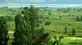
View over the plain of Culpina to the Salar de Culpina

Flamingos on the Salar de Culpina


Web links
- Relief map of the La Cueva region 1: 50,000 Instituto Geográfico Militar Bolivia (PDF; 2.8 MB) ( accessed April 13, 2017 )