Camargo (Chuquisaca)
| Camargo | ||
|---|---|---|
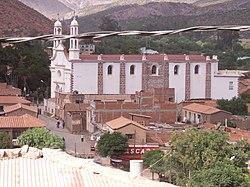
 Camargo Cathedral |
||
| Basic data | ||
| Residents (state) | 5173 pop. (2012 census) | |
| rank | Rank 84 | |
| height | 2421 m | |
| Post Code | 01-0701-0100-1001 | |
| Telephone code | (+591) 4629 | |
| Coordinates | 20 ° 38 ′ S , 65 ° 13 ′ W | |
|
|
||
| politics | ||
| Department | Chuquisaca | |
| province | Nor Cinti Province | |
| climate | ||
 Climate diagram Camargo |
||
Camargo is a small town in the Chuquisaca department in the South American Andean state of Bolivia .
Location in the vicinity
Camargo is the central place of the district ( Bolivian : Municipio ) Camargo and seat of the administration of the province Nor Cinti . The city is embedded in north-south mountain ranges at an altitude of 2421 m on the Río Chico , which flows downriver to the Rio Grande de Cinti (Río Tumusla and Río Cotagaita). Further south, this river joins the Río San Juan del Oro to form the Río Camblaya, which is called the Rio Pilaya further downstream and finally flows into the Río Pilcomayo .
geography
Camargo is located on the southwestern foothills of the Bolivian Cordillera Central , between the Altiplano in the west and the Bolivian lowlands in the east. The climate is a cool, moderate mountain climate with a typical time of day climate , in which the mean temperatures fluctuate more strongly during the day than during the year.
The annual average temperature in the region is just under 14 ° C (see Camargo climate diagram), the monthly averages fluctuate between just under 10 ° C in June / July and 16 ° C from November to March. The annual precipitation is 400 mm and has seven arid months from April to October with monthly values below 20 mm, significant monthly precipitation only falls from December to February with values of 80 to 90 mm each.
Transport network
Camargo is 350 kilometers by road south of Sucre , the capital of the department.
The 1215 kilometer long, now asphalted highway Ruta 1 runs through Camargo and leads from the Peruvian border on Lake Titicaca in the north to the Argentine border in the south.
population
The city's population has increased by around two thirds over the past two decades:
| year | Residents | source |
|---|---|---|
| 1992 | 3,789 | census |
| 2001 | 4,502 | census |
| 2012 | 5,173 | census |
Individual evidence
- ↑ INE - Instituto Nacional de Estadística Bolivia 1992 ( Memento of the original from April 23, 2014 in the Internet Archive ) Info: The archive link was inserted automatically and has not yet been checked. Please check the original and archive link according to the instructions and then remove this notice.
- ↑ INE - Instituto Nacional de Estadística Bolivia 2001 ( Memento of the original from September 24, 2015 in the Internet Archive ) Info: The archive link has been inserted automatically and has not yet been checked. Please check the original and archive link according to the instructions and then remove this notice.
- ↑ INE - Instituto Nacional de Estadística Bolivia 2012 ( Memento of the original from July 22, 2011 in the Internet Archive ) Info: The archive link has been inserted automatically and has not yet been checked. Please check the original and archive link according to the instructions and then remove this notice.
Web links
- Relief map 6532-II of the Camargo region 1: 50,000 (PDF; 2.60 MB)
- Relief map of the Camargo region 1: 250,000 (PDF; 10.45 MB)
- Municipio Camargo - General Maps No. 10701
- Municipio Camargo - detailed map and population data (PDF; 452 kB) ( Spanish )
- Departamento Chuquisaca - Social data (PDF; 4.21 MB) ( Spanish )
