
Salas y Gomez
| Salas y Gomez | |
|---|---|
 |
|
| Waters | Pacific Ocean |
| Geographical location | 26 ° 28 '17 " S , 105 ° 21' 55" W |
 |
|
| length | 770 m |
| width | 500 m |
| surface | 15 ha |
| Highest elevation | 30 m |
| Residents | uninhabited |
 |
|
Salas y Gómez (also Sala y Gómez , Spanish Isla Salas y Gómez , Rapanui : Motu Motiro Hiva ) is an island in the Pacific Ocean , 391 km east of Easter Island at latitude 26 ° 28 'south and longitude 105 ° 22' west. The island got its name from the Spanish captains José Salas Valdés , who sighted the island on August 23, 1793, and José Manuel Gómez , who explored the island more closely in 1805; It was first sighted by Europeans possibly as early as 1687, namely by the English privateer Edward Davis . The uninhabited island has belonged to Chile since 1808 and has been administered from Easter Island since March 1, 1966 (until 1974 Department Isla de Pascua , since July 25, 1974 Provincia de Isla de Pascua ). In 1994 the Chilean Navy installed an automatic beacon and a tsunami warning system.
geography
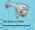
Island map

Easter Island and Salas y Gómez (1870)


The island, about 3,210 km from the Chilean mainland, is of volcanic origin and relatively young with an age of less than 2 million years. It is the summit of a mountain that rises about 3500 m from the sea floor from the Salas-y-Gómez ridge . Salas y Gómez consists of two larger, almost bare rocks, which are connected by a narrow isthmus . The island is 0.15 km², with a length of 770 m and a maximum width of 500 m. There are no natural sources of fresh water, but an approximately 200 m² depression on the larger eastern rock sometimes contains fresh water. At its highest point, in the south of the eastern rock, less than 30 meters from the coast, the island reaches a height of 30 m . Landing with boats is considered difficult. About 1.1 km northeast of the island, only 25 m below sea level , is the Bajo Scott , another submarine peak .
Flora and fauna
Together with Easter Island, Salas y Gómez belongs to the Rapa Nui subtropical broadleaf forests ecoregion , although the island itself is not forested. Because the island is heavily sprayed by salt water, four types of land plants grow there only in better protected places, especially striped ferns ( asplenium ). The island is a breeding places for many seabirds, including Christmas Shearwater ( Puffinus nativitatis ) Bindenfregattvögel ( Fregata minor ), Masked Booby ( Sula dactylatra ), Sooty Terns ( Onychoprion fuscatus ) Noddis ( Anous stolidus ), White-throated Sea Runner ( Nesofregetta fuliginosa ), Rotschwanz -Tropical birds ( Phaethon rubricauda ), fairy terns ( Gygis alba ), red-footed boobies ( Sula sula ) and gray noddies ( Anous albivitta ).
Others
The island became famous through the poem by Adelbert von Chamisso , who passed it on his circumnavigation.
literature
- Fundamentos para establecer Parque Marino Salas y Gómez . Informe Tecnico (R. Pesq.) No. 81/2010. Gobierno de Chile - Subsecretaría de Pesca, August 2010 (Spanish, online [PDF; 729 kB ]).
Web links
- The Islands - Salas y Gómez. In: Easter Island / Salas y Gomez 1–22 September 1995 Cordell Expeditions (English).
- Sala y Gomez in the Global Volcanism Program of the Smithsonian Institution (English).
Individual evidence
- ↑ Chile. Easter Island (Isla de Pascua / Rapa Nui). In: World Statesmen.org. Retrieved May 29, 2017 .
- ↑ Fundamentos para establecer Parque Marino Salas y Gómez . Informe Tecnico (R. Pesq.) No. 81/2010. Gobierno de Chile - Subsecretaría de Pesca, August 2010, Section 2.1.2: Geología, p. 2 (Spanish, online [PDF; 729 kB ]).
- ↑ Adelbert von Chamisso Salas y Gomez on Zeno.org
- ^ Adelbert von Chamisso: Journey around the world: The diary 1815-1818 . (First printed in 1836), Karl-Maria Guth (Ed.), Hofenberg / BoD, Berlin 2015, ISBN 978-3843075046 , p. 70