Salisbury Highway
| Salisbury Highway | |
|---|---|
 
|
|
| Basic data | |
| Operator: | DTEI |
| Start of the street: |
A52 Main North Road Elizabeth Vale ( SA ) ( 34 ° 45 ′ S , 138 ° 41 ′ E ) |
| End of street: |
|
| Overall length: | 12 km |
|
States : |
|
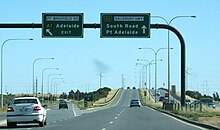
| Salisbury Highway at Parafield Gardens, heading southwest | |
The Salisbury Highway is an urban highway in the northern suburbs of Adelaide in the center of the Australian state of South Australia . It connects Main North Road in Elizabeth Vale with the Port River Expressway and South Street in Wingfield .
course
The highway is developed as a four-lane road. It branches off the Main North Road (A52) to the west as John Rice Avenue labeled A13 State Road in Elizabeth Vale and passes the suburb of Salisbury to the west. From that point on it is referred to as the Salisbury Highway . It runs parallel to Main North Road to the southwest, crosses Kings Road (A18) and reaches Port Wakefield Road (NA1). From there, the Salisbury Highway is run as the A13 national road. It initially continues to the southwest, along the salt marshes of the Barker Inlet , and then turns west. It ends at the western end of the salt marshes and becomes the Port River Expressway (A9).
The A13 national road leads south as South Street and is renamed the A13 state road from the junction with Grand Junction Road (A16).
Important intersections
-
Starting on Main North Road
 : Elizabeth Vale as John Rice Avenue
-
 Phillip Highway: Salisbury Park
-
 Commercial Road: Salisbury - further than Salisbury Highway
-
 Park Terrace / Waterloo Corner Road: Salisbury
-
 Kings Road
  : Parafield Gardens
-
 Port Wakefield Road
  : Dry Creek - wider than
-
 Ends at the junction with South Road
  and the Port River Expressway
  : Wingfield
source
Steve Parish: Australian Touring Atlas . Steve Parish Publishing. Archerfield QLD 2007. ISBN 978-1-74193-232-4 . P. 64
Individual evidence
- ↑ 2006 Adelaide & Surrounds Street Directory, 54th Edition . Gregory's ,, ISBN 0-7319-1842-8 .

