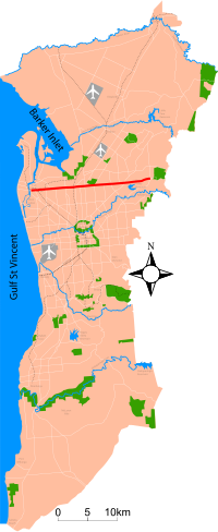
Grand Junction Road
| Grand Junction Road | |
|---|---|
 
|
|
| map | |
| Basic data | |
| Operator: | Transport SA |
| Start of the street: |
Vista ( Adelaide ) ( SA ) ( 34 ° 50 ′ S , 138 ° 43 ′ E ) |
| End of street: |
Queenstown ( Adelaide ) ( SA ) ( 34 ° 51 ′ S , 138 ° 31 ′ E ) |
| Overall length: | 21 km |
|
States : |
|
| View from Rosewater down Grand Junction Road towards the Adelaide Hills | |
The Grand Junction Road is a main road in the northern Australian city of Adelaide in South Australia . This longest east-west link in the Adelaide area is 9 km north of the city center.
course
It runs from Port Adelaide to the east as a four-lane road (from Tolley Road in Hope Valley only two-lane) 21 km to the foot of the Adelaide Hills . Its western end is at the junction with Old Port Road , 300 m east of a dam that separates the Port River from West Lakes . The 2.4 km long stretch of road west of Old Port Road to Semaphore is called Bower Road . The east end of Grand Junction Road is in the Hope Valley suburb at the intersection of Hancock Road and Lower North East Road , just before the latter continues into the Adelaide Hills via Anstey Hill Recreation Park to Houghton and Inglewood .
history
The street was originally called Junction Road , but got its current name after a small settlement with a school and inn, which was called The Grand Junction since at least 1850 . The settlement was at the junction of the roads to Adelaide, Port Adelaide and the cities in the north of the Adelaide Plain.
Important intersections
There are a number of important junctions along Grand Junction Road. The largest of these is the original Grand Junction in Gepps , where Main North Road (A1 / A20) and Port Wakefield Road (A1) meet. Main North Road comes from the south and heads northeast towards Parafield, Elizabeth and Gawler , while Port Wakefield Road begins at this junction and heads north across the Northern Adelaide Plain to Port Wakefield .
-
Start of
 at the junction with Lower North East Road
 : Vista
-
 North East Road
  : Holden Hill
-
 Hampstead Road
  / Briens Road: Northfield - street numbering changes to
-
 Port Wakefield Road
  / Main North Road :
 Gepps Cross
-
 Cavan Road
  : Kilburn
-
 South Road :
 Regency Park - street numbering changes to
-
 Hanson Road: Mansfield Park - North to
-
 Port Road
  : Alberton
-
 Ends at the junction with Old Port Road : Queenstown
-
-
 further than Bower Road .
The road officially belongs to the National Highway System, therefore has a corresponding road sign and is maintained by the federal government. The National Highway leads south from Port Augusta , at the junction of Salisbury Highway / South Road, along Grand Junction Road via Gepps (where it joins the Main North Road on another National Highway (A20) heading northeast Sydney leads, meets) to the junction with Hampstead Road a few kilometers further, where it turns south, towards Melbourne . From there, Grand Junction Road continues without a national road sign.
Level crossings
The construction of the railway system in the Adelaide area north of the city center leads to some former and still operational junctions of the Grand Junction Road with railway lines. These are:
- The bridge over the Adelaide – Outer Harbor line in Alberton
- A level crossing on the Adelaide – Dry Creek line in Rosewater
- A former level crossing on Glenroy Street and Eastern Parade in Pennington and Ottoway (on the former Finsbury Railway Line)
- The bridge over the Adelaide – Gawler line and the ARTC main line to Port Augusta in Kilburn and Wingfield
- The O-Bahn underpass at Holden Hill
Educational institutions
A number of schools and other educational institutions are right on Grand Junction Road:
- Enfield High School in Enfield
- Gepps Cross Girls School in Gepps
- St. Paul's College in Gilles Plains
- Tauondi College in Port Adelaide , across from Alberton
- Torrens Valley Christian School in Hope Valley
source
Steve Parish: Australian Touring Atlas . Steve Parish Publishing. Archerfield QLD 2007. ISBN 978-1-74193-232-4 . P. 64
Individual evidence
- ↑ 2003 Adelaide Street Directory, 41st Edition . UBD (A Division of Universal Press Pty Ltd), 2003, ISBN 0-7319-1441-4 .
- ↑ H. John Lewis: ENFIELD THE NORTHERN VILLAGES and . The corporation of the City of Enfield , South Australia 1985, ISBN 0-85864-090-2 , p. 157.


