
Port River Expressway
| Port River Expressway | |
|---|---|

|
|
| Basic data | |
| Operator: | DTEI |
| Start of the street: |
Wingfield ( Adelaide ) ( SA ) ( 34 ° 50 ′ S , 138 ° 34 ′ E ) |
| End of street: |
|
| Overall length: | 5.5 km |
|
States : |
|
 |
|
The Port River Expressway is an urban highway in the center of the Australian state of South Australia , in the northern suburbs of Adelaide . It connects Port Adelaide and the LeFevre Peninsula with the northern suburbs of Adelaide and via the Salisbury Highway (A13) to the major highways Port Wakefield Road (NA1) and Northern Expressway (NM20) to Perth and Sydney .
Not all exits on the Port River Expressway are highway level; some intersections also have traffic lights. Therefore this street was only given the numbering A9 instead of the M-numbering usual for motorways.
construction
The Port River Expressway was built in three phases:
- Section 1 (opened July 19, 2005): 5.5 km long, four-lane motorway between Francis Street and South Road with uneven connections to South Road, Hanson Road and Eastern Parade.
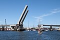
- Section 2 (opened on August 3, 2008): Four-lane high bridge as a drawbridge over the Port River between Dock 1 and 2. It connects Section 1 at the Francis Street junction with Victoria Road on the LeFevre Peninsula.
- Section 3 (opened in June 2008): Single-lane high-rise railway bridge as a drawbridge over the Port River north of the road bridge with connections to the existing railway network in the Adelaide region.
The Port River Expressway is now an efficient connection for passenger and freight traffic from the northern suburbs to the largest port facilities of South Australia in Port Adelaide and Outer Harbor.
Exits and crossings
|
Port River Expressway |
|||
| Exits to the west | Distance from Salisbury Highway (km) |
Eastbound exits | |
| Regency Park, Adelaide South Road |
0.0 km |
End of Port River Expressway further than Salisbury Highway to & |
|
|
Start of the Port River Expressway off the Salisbury Highway |
Regency Park, Adelaide South Road |
||
| Ottoway Wingfield Waste & Recycling Center Hanson Road |
1.5 km | Ottoway Wingfield Waste & Recycling Center Hanson Road |
|
| North Arm, Torrens Island Eastern Parade |
3.8 km | North Arm, Torrens Island Eastern Parade |
|
| PORT FLAT FREIGHT RAIL LINE | PORT FLAT FREIGHT RAIL LINE | ||
|
Port Adelaide Perkins Drive |
4.5 km |
Port Adelaide Perkins Drive |
|
|
Drawbridge TOM 'DIVER' DERRICK BRIDGE no exit |
5.0 km |
Drawbridge TOM 'DIVER' DERRICK BRIDGE no exit |
|
|
Port Adelaide , Nelson Street Semaphore |
5.5 km |
Start of the Port River Expressway from Victoria Road |
|
|
End of Port River Expressway further than Victoria Road to Outer Harbor |
Port Adelaide , Nelson Street Semaphore |
||
Gallery images
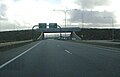
Port River Expressway just before the South Street exit.

Port River Expressway heading east just before the Eastern Parade exit

Tom “Diver” Derrick Bridge over the Port River
The Mary MacKillop Railway Bridge next to the Tom "Diver" Derrick Road Bridge.

Junction with South Road


Web links
- Port River Expressway . Transport SA ( Memento of March 10, 2007 in the Internet Archive )
source
- Steve Parish: Australian Touring Atlas . Steve Parish Publishing. Archerfield QLD 2007. ISBN 978-1-74193-232-4 . P. 64
Individual evidence
- ^ Stage 1 of the Port River Expressway . South Australian Department for Transport, Energy and Infrastructure. February 24, 2006. Archived from the original on August 25, 2006. Retrieved on February 4, 2007.
- ^ Stage 2 of the Port River Expressway . South Australian Department for Transport, Energy and Infrastructure. August 17, 2007. Archived from the original on December 21, 2007. Retrieved on August 3, 2008.
- ^ Stage 3 of the Port River Expressway . South Australian Department for Transport, Energy and Infrastructure. August 17, 2007. Archived from the original on December 21, 2007. Retrieved on May 25, 2008.
- ^ Port River Expressway, Adelaide, Australia . Retrieved November 27, 2011.