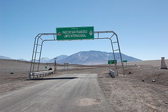
San Francisco Pass
| San Francisco Pass | |||
|---|---|---|---|
|
|
|||
| Compass direction | east | west | |
| Pass height | 4726 m | ||
| Región de Atacama , Argentina | Catamarca Province , Chile | ||
| Mountains | To the | ||
| map | |||
|
|
|||
| Coordinates | 26 ° 52 ′ 35 ″ S , 68 ° 18 ′ 5 ″ W | ||
The San Francisco Pass ( Spanish Paso de San Francisco ) is a pass over the Andes that connects Argentina and Chile . The highest point is at 4726 m. The road RN 60 (in Argentina) or CH-31 (in Chile) running over the pass connects the province of Catamarca with the Región de Atacama .
photos
Web links
Commons : San Francisco Passport - Collection of Pictures, Videos, and Audio Files


