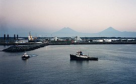
Puerto San José
| Puerto San José | ||
|---|---|---|
|
Coordinates: 13 ° 56 ′ N , 90 ° 49 ′ W Puerto San José on the map of Guatemala
|
||
| Basic data | ||
| Country | Guatemala | |
| Department | Escuintla | |
| City foundation | 1853 | |
| Residents | 25,000 | |
| Detailed data | ||
| height | 3 m | |
| Waters | Pacific, Canal Chiquimulilla | |
| Time zone | UTC −6 | |
| City patron | Virgen del Mar | |
| Puerto Quetzal | ||
Puerto San José is a port city on the Pacific coast of Guatemala and has about 25,000 inhabitants. Puerto San José is the administrative seat of the municipality ( Municipio ) San José in the Escuintla Department .
Location and climate
The city is located about 110 km south of Guatemala City at the beginning of the CA 9 motorway to Guatemala City. The climate is tropical hot, the rainy season lasts from May to October.
Economy and tourism
Puerto San José was the most important Pacific port in Guatemala until the 1970s and the terminus of the railway line coming from the Atlantic port of Puerto Barrios . After the construction of the modern container port of Puerto Quetzal , just a few kilometers to the east, the city lost much of its economic importance. The Puerto Quetzal industrial complex is the main employer in the region. Tourism also plays an important role, thanks in particular to the holiday resorts in Chulamar and Likín.
Puerto San José has a modernized airport of regional importance. It is used by general aviation and served by foreign charter airlines. It is the official alternate airport for Guatemala City International Airport . A paratrooper association of the armed forces of Guatemala is located in Puerto San José .
history
In the colonial times, the port of Iztapa, already used by Pedro de Alvarado and located 13 km east of Puerto San José, was Guatemala's gateway to the Pacific. Puerto San José was not founded until 1853. The first inhabitants came mainly from Amatitlán and Escuintla . In 1982, Hurricane David wreaked havoc in Puerto San José.

