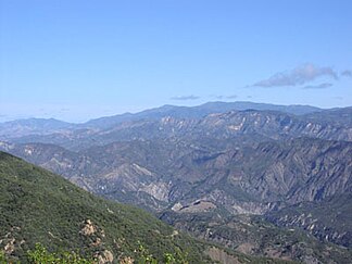
San Rafael Mountains
| San Rafael Mountains | ||
|---|---|---|
|
San Rafael Mountains |
||
| Highest peak | Big Pine Mountain ( 2079 m ) | |
| location | California (USA) | |
| part of | Transverse ranges | |
|
|
||
| Coordinates | 34 ° 43 ′ N , 119 ° 44 ′ W | |
The San Rafael Mountains are a mountain range in Santa Barbara County in the US state of California . They are part of the Transverse Ranges , which in turn are part of the Pacific Coast Ranges .
The highest mountain in the mountain range is Big Pine Mountain with a height of 2,079 meters, followed by San Rafael Mountain at 2,010 meters and McKinley Mountain at 1,896 meters.
Most of the mountain range is in the Los Padres National Forest , the northern slopes are part of the remote San Rafael National Wilderness Area. The mountains are steep and rugged. The lower slopes are covered with impenetrable chaparall . Conifers grow in the higher areas . Snowfalls can be expected on the mountain peaks above 1,800 meters in winter, otherwise the San Rafael Mountains have a Mediterranean climate with warm, dry summers and mild, rainy winters.
To the southwest of the mountain range is Zaca Lake , the only natural lake in Santa Barbara County .
The San Rafael Mountains were first settled by Indians from the Chumash tribe. Rock painting in remote areas of the mountain range is evidence of their customs . In earlier centuries mercury was mined in the southern part of the mountain range . Due to the health hazards of the toxic heavy metal, which are now known, environmentalists are currently trying to find out whether remediation is necessary and feasible.
Web links
- US Geological Survey (English)
- San Rafael Mountains on Peakbagger.com (English)
Individual evidence
- ↑ San Rafael National Wilderness Area at www.wilderness.net (accessed December 2, 2009)
- ^ Conservation Element. Santa Barbara County Comprehensive General Plan. Plants p. 114ff. (pdf document, accessed December 2, 2009; 6.9 MB)
- ↑ Open Space Element. Santa Barbara County Comprehensive General Plan, p. 71 (pdf document, accessed December 2, 2009; 2.4 MB)
- ^ Conservation Element. Santa Barbara County Comprehensive General Plan. Archaeological Sites p. 227ff. (pdf document, accessed December 2, 2009; 6.9 MB)
- ^ Conservation Element. Santa Barbara County Comprehensive General Plan. Mineral Resources p. 157ff. (pdf document, accessed December 2, 2009; 6.9 MB)

