Sandefjord Bay
| Sandefjord Bay | ||
|---|---|---|
|
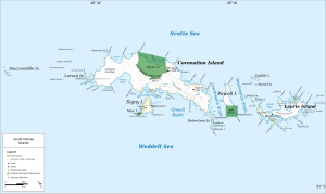
Map of Coronation Island (center) with Sandefjord Bay to the west |
||
| Waters | Weddell Sea | |
| Land mass | Coronation Island and Monroe Island , South Orkney Islands | |
| Geographical location | 60 ° 37 ′ 0 ″ S , 46 ° 3 ′ 0 ″ W | |
|
|
||
| Islands | Mainsail Rock , Sphinx Rock The Twins | |
The Sandefjord Bay ( Norwegian Sandefjordhavna , Sandefjordhafen ' ) is a narrow and 3 km long bay in the archipelago of the South Orkney Islands . It extends northeast-southwest between the western end of Coronation Island and Monroe Island .
The British whaling captain George Powell and his American counterpart Nathaniel Palmer discovered them and roughly mapped them in December 1821. The name of the bay after the town of Sandefjord , stronghold of the Norwegian whaling industry, apparently goes back to the Norwegian whaling captain Petter Sørlle in 1912. In 1933, participants in the British Discovery Investigations surveyed the bay.
Web links
- Sandefjord Bay in the Geographic Names Information System of the United States Geological Survey (English)
- Sandefjord Bay on geographic.org (English)

