Sandhead
| Sandhead | ||
|---|---|---|
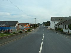
| Main Street from Sandhead | ||
| Coordinates | 54 ° 48 ′ N , 4 ° 58 ′ W | |
|
|
||
| administration | ||
| Post town | STRANRAER | |
| ZIP code section | DG9 | |
| prefix | 01776 | |
| Part of the country | Scotland | |
| Council area | Dumfries and Galloway | |
| British Parliament | Dumfries and Galloway | |
| Scottish Parliament | Galloway and West Dumfries | |
Sandhead is a small town in the Scottish Council Area Dumfries and Galloway . It is located around ten kilometers south of Stranraer on the Rhins of Galloway peninsula . Sandhead hugs a sandy cove along Luce Bay .
history
Kirkmadrine Church is about two kilometers southwest of Sandhead . Presumably it is a site that has been used since early Christian times. This is indicated by cross finds that are dated to the 5th to 6th centuries. It is possible that there was even a monastery at this location. Other finds date from the 8th to 12th centuries.
In the 1730s the of was near the village of William Adam designed mansion Balgreggan House . It was canceled in 1966.
traffic
The A716 touches Sandhead in the west. It connects the village to the A75 and the A77 in Stranraer. The B7042 , which leads to Portpatrick, joins the northern edge .
Individual evidence
- ↑ a b Entry in the Gazetteer for Scotland
- ↑ Listed Building - Entry . In: Historic Scotland .
- ↑ Entry on Kirkmadrine Church in Canmore, the database of Historic Environment Scotland (English)

