Sandy's Mill
| Sandy's Mill
|
||
|---|---|---|
|
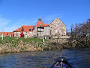
The Mill (Miller's House) as seen from the River Tyne |
||
| Location and history | ||
|
|
||
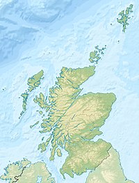
| Coordinates | 55 ° 58 ′ 7 ″ N , 2 ° 43 ′ 20 ″ W | |
| Location | near Haddington , East Lothian , Scotland , United Kingdom | |
| Waters | Tyne | |
| Built | 18th century | |
| Shut down | 1940s | |
| Status | Structure and technology preserved, out of order | |
| technology | ||
| use | Flour mill | |
| Grinder | 2 grinding courses | |
| drive | Watermill | |
| water wheel | 1 × medium-sized | |
Sandy's Mill is a former watermill near the Scottish town of Haddington in the East Lothian Council Area . The building, built in the second half of the 18th century, was included in the Scottish Monuments List in 1971 in the highest category A. It was first recorded on a map from 1799. It is possible that there was a previous structure at the site which served to supply Gilmerton House . Operations ceased in the early 1940s.
description
Sandy's Mill is isolated around 3.5 kilometers northeast of Haddington. It is accessible via a spur road from the A199 , which runs directly parallel to the A1 . The three-story building of the flour mill has an elongated floor plan. A one-story threshing mill with a hipped roof was later added on the west side . The masonry is made of quarry stone. The entrance is on the north side.
The mill is near the River Tyne . The water of the Tyne is branched off 200 m above the mill and drives a medium-sized water wheel on the south side. This has an outer diameter of 4.26 m and a width of 1.5 m. Originally it was equipped with 30 blades, each three centimeters thick. As a result of the decade-long standstill, the mill wheel is largely silted up today. The water wheel served to drive two grinding cycles .
Individual evidence
- ↑ a b c Listed Building - Entry . In: Historic Scotland .
Web links
- Entry on Sandy's Mill in Canmore, Historic Environment Scotland's database


