Sansankoto Island
| Sansankoto Island | ||
|---|---|---|
|
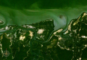
NASA World Wind satellite image : The Gambia flows in the image section in a westerly direction, the left bank of the river can be seen. |
||
| Waters | Gambia (river) | |
| Geographical location | 13 ° 15 '50 " N , 16 ° 23' 31" W | |
|
|
||
| length | 5.5 km | |
| width | 3.5 km | |
| Residents | uninhabited | |
Sansankoto Island is an inland island of the Gambia River in the West African state of Gambia .
geography
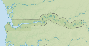
Near the left bank of the Gambia, at the confluence of the Brefet Bolong and the Bulok Bolong , about 30 kilometers upstream from Banjul is the approximately three and a half by five and a half kilometers large uninhabited island of Sansankoto Island. In the Gambia, which is about six kilometers wide at this point, in the middle of the river, about six kilometers northwest of it, is the historically significant island of James Island . Opposite on the other right bank of Sansankoto Island are the places Albreda and Juffure .
The place Brefet is about three kilometers southwest of the island. There was a British trading post nearby in the 1780s .
Separate, second island
To the west of this island there is now a second island around 3400 meters long and 800 meters wide. It originally belonged together to Sansankoto Island and on most maps they are connected together by a land bridge. Due to erosion, the island broke apart in the second half of the 20th century, leaving a gap of around 400 meters. A name for the separated island is neither recorded nor given.
See also
literature
- Stephen C. Stringall, Dody Broyles: Gambia. International Travel Maps, Vancouver 2003, ISBN 1-55341-217-6 (map, 96 × 61 cm, 1: 350,000)

