
Sant'Andrea (Venice)
| Sant'Andrea | ||
|---|---|---|
 |
||
| Waters | Venice lagoon | |
| Geographical location | 45 ° 26 '4 " N , 12 ° 22' 52" E | |
|
||
| length | 310 m | |
| width | 165 m | |
| surface | 2 ha | |
| Residents | uninhabited | |
| main place | Forte di Sant'Andrea (historical) |
|

Sant'Andrea is a small island in the Venice lagoon 1,100 meters east of the old town of Venice and 100 meters east of the island of La Certosa . It is only separated from Vignole , the southern extension of which it can be seen, by a six to 30 meter wide waterway and connected by a nearly ten meter long pedestrian bridge. Another bridge in the south, shown on maps, can no longer be seen on current satellite images. From the port of Porto di San Nicolo in the northern Nehrungsinsel Lido Sant'Andrea is through the 240 meter wide canal de San Nicolò separately.
The island is 310 meters long and up to 165 meters wide, and has an area of around two hectares .
fortress
On the island is the Forte di Sant'Andrea, a 16th century fortress to defend Venice .
Giacomo Casanova was arrested there for a few months in 1743 on the orders of Abate Grimani and taken into custody there.
Airfield
Although located on and on the neighboring island of Vignole, the former seaplane base of Venice was named after the island of Sant'Andrea. If one regards Sant'Andrea only as a continuation of Vignole, the latter actually consists of three islands separated by canals. Sant'Andrea lies at the end of the canal, which was used by flying boats at the time and is now part of a military base also known as "Sant'Andrea" .

Fort Sant'Andrea

"Sant'Andrea" designated military base .
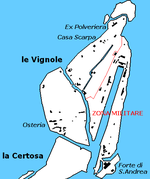
San'Andrea, in the southeast of Vignole . The canal in the Zona Militare is the former airfield.

_-_Caserma_Sant%27Andrea.jpg)
