
Saugasse

The Saugasse is a gorge-like steep gully in the Berchtesgaden Alps , through which the alpine hiking trail leads from St. Bartholomä into the Steinerne Meer to the Kärlingerhaus .
Characteristic
The Saugasse is about halfway between the west bank of the Königssees and the Kärlingerhaus. The entrance to the Saugasse is about 980 meters above sea level on the south-western edge of the former pasture area of the now dilapidated Unterlahneralm. From there, the lane pulls up in a south-westerly direction on the north-west slope of the Simetsberg and is flanked on the opposite side by the rocky slopes of the Graskopf and the Gjaidkopf and the tooth of the Schneibers. Over a distance of around 600 meters, a good 300 meters in altitude are overcome. The route of the hiking trail leads through this up to 40 degree steep terrain in 32 serpentines . At the upper end of the Saugasse, the hiking trail leads into the former pasture area of the Oberlahneralm, which is now also abandoned. At its southern end, the hiking trail bends to the southeast and leads into another ascent with numerous serpentines. This section of the trail is known as the Kleine Saugasse and begins at an altitude of around 1500 meters. The steepness of this section of the path is, however, much more moderate than that of the Saugasse, so that here over a length of about half a kilometer only 100 meters of altitude are overcome.
photos
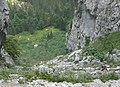
The lower part of the Saugasse and the southeastern area of the abandoned Unterlahneralm

The upper end of the Saugasse with access to the former pasture area of the Oberlahneralm

The former pasture area of the abandoned Oberlahneralm
.jpg)
.jpg)

literature
- Bernhard Kühnhauser: Alpine Club Guide Berchtesgaden Alps with Hochkönig . 20th edition. Bergverlag Rother , Munich 2011, ISBN 978-3-7633-1127-9 .
- Ernst Höhne: hut goals . Weltbild Verlag, Augsburg 1995, ISBN 3-89350-994-1 .
cards
- Alpine Club Card No. BY 21 - Berchtesgaden National Park, Watzmann. Scale 1: 25,000, ISBN 978-3937530468
- Alpine Club Card No. 10/1 - Steinernes Meer. Scale 1: 25,000, ISBN 978-3928777261
- Topographic map, sheet 8443 - Königssee. Bavarian Land Surveying Office, scale 1: 25,000, ISBN 978-3-86038-308-7
Web links
Coordinates: 47 ° 31 ′ 1 ″ N , 12 ° 55 ′ 59 ″ E