Schatzberg (Dießen am Ammersee)
| Schatzberg | ||
|---|---|---|
|
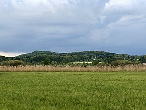
Schatzberg (left) and Burgberg (right) seen from Ammermoos |
||
| height | 676.6 m above sea level NHN | |
| location | Bavaria , Germany | |
| Coordinates | 47 ° 55 '45 " N , 11 ° 5' 0" E | |
|
|
||
| rock | Nagelfluh | |
| Age of the rock | Worm Ice Age | |
| particularities | Refuge at the summit | |
The Schatzberg is a 677 m high moraine hill from the Würme Ice Age in the area of the market in Dießen am Ammersee in the Upper Bavarian district of Landsberg am Lech .
Location and surroundings
The Schatzberg is located west of the Ziegelstadl district of Markt Dießen am Ammersee, the distance to Ammersee (533 m) is around 3 km.
If the weather permits, the summit offers a magnificent view of the Alps .
geology
In its present form the Schatzberg emerged in the Wurm Age , when the glacier abraded Ammersee only the south side of the Nagelfluhfelsens. The adjoining castle hill is mainly made up of tertiary loess , on which gravel and Nagelfluh rests.
Names
In the Middle Ages the mountain was called Irsingsberg , the current name can only be traced back to 1788.
The northern castle hill was called Shonenberg .
history
On the summit of the Schatzberg there was probably a palisade fortress in the Middle Ages to defend the lower castle on today's castle hill (648 m). This is located about 600 m northwest of the summit with the early medieval Sconenburg castle stables of the Counts of Dießen-Andechs .
When Count Heinrich II. Von Dießen bequeathed his property around and in Dießen to the monastery , he had the razing of the castle recorded in the deed of donation in 1158 . However, in the 14th century there was still a farmyard on the castle hill and it wasn't until the beginning of the 20th century that the last tuff blocks of the former castle were removed. From 1860 the Burgstall was also used as a gravel pit and as a waste dump until 1970. Today only a small tuff wall with a plaque erected in 1999 reminds of the Sconenburg.
In the immediate vicinity of the castle stable is the castle chapel, built in 1792, which was only enlarged to its present size in 1862.
Below is the Mechtildisbrünnlein from 1885.
Individual evidence
- ^ Geology Atlas Bavaria. Accessed January 31, 2019 .
- ^ BayernAtlas. Accessed January 30, 2019 .
- ↑ M. Aquinata Schnurer OP: Home book of the market in Dießen am Ammersee . Ed .: Markt Dießen am Ammersee. Jos. C. Huber KG, Dießen am Ammersee 1976, p. 24 .
- ↑ Diessen Castle and Treasure Mountain. Retrieved February 6, 2019 .
- ↑ Manuel Raff: The castle hill near Dießen am Ammersee and the former ancestral castle of the Counts of Dießen-Andechs . 1994, p. 57-77 .
- ↑ Armin Greune: The promise of the haunted virgin . In: sueddeutsche.de . January 20, 2017, ISSN 0174-4917 ( sueddeutsche.de [accessed February 6, 2019]).
- ↑ Markt Diessen am Ammersee - churches and chapels. Accessed January 31, 2019 .


