Shelfak
Shelfak ( ancient Egyptian : Uaf-chasti ( Wˁf-ḫ3s.tj ) who bows down the foreigners ) is a border fortress of ancient Egypt in Nubia and is located on the territory of today's Sudan . It is located about five kilometers north of Uronarti .
The attachment
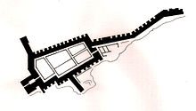
The fortress is on the west side of the Nile . It is constructed similarly to the fort of Uronarti, but is only slightly smaller in its dimensions. The fortress consisted of a main part with various barracks , administration buildings, storage facilities and strong walls almost five meters thick. In the east there is a wing that is almost 100 m long and consists of only one wall with bastions . This wing ran parallel to the Nile. There was a small Middle Kingdom cemetery next to the fortress . A few finds also prove the presence of Roman Nubians.
Shelfak was made by Pharaoh Sesostris III. (1878-1842 / 1840 BC) and is still there today. Excavations took place in 1931 under the direction of Harvard University and the Museum of Fine Arts, Boston . Noel F. Wheeler was in charge of the excavation . Claudia Näser from University College London has been digging here since 2017 .
See also
literature
- Dows Dunham (Ed.): Uronarti, Shalfak, Mirgissa (= Second Cataract Continuation Volume 2). Excavated by George Andrew Reisner , Noel F. Wheeler. Museum of Fine Arts, Boston MA 1967, pp. 115–137, map X.
Individual evidence
- ↑ Claudia Näser: Shalfak: a Middle Kingdom fortress in Lake Nubia. In Egyptian Archeology. Volume 52, spring 2018, pp. 4–9.
Web links
- The Middle Kingdom Egyptian Fortresses in Nubia. Article on the Egyptian border fortresses in Nubia (English) On: yare.org ( Memento from March 30, 2016 in the Internet Archive )
- Aerial view of the fortress on. flickr.com ; accessed on March 9, 2018.
Coordinates: 21 ° 32 ′ 30 ″ N , 31 ° 2 ′ 25 ″ E
