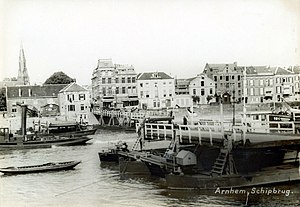
Arnhem ship bridge
Coordinates: 51 ° 58 ′ 45 ″ N , 5 ° 54 ′ 1 ″ E
| Arnhem ship bridge | |
|---|---|
| The Arnhem ship bridge 1934 | |
| Crossing of | Nederrijn |
| place | Arnhem |
| construction | Ship bridge |
| completion | 1603 |
| closure | 1935 |
| Open ship bridge | |
The ship bridge Arnhem ( Dutch Schipbrug Arnhem ) crossed the Nederrijn in the Dutch city of Arnhem . It was in the west of the city center on the site of today's Nelson Mandela Bridge .

It was laid out in 1603 to make the town more accessible for the Betuwe farmers and Nijmegen traders , who previously had to rely on ferries . It was repeatedly destroyed by floods and wars. The aging of the ships also meant that they had to be renewed again and again.
Until the construction of the Rijnbrug in 1935, today's John Frost Bridge , it was the only river bridge in Arnhem.
In the event of storms and impending ice drift in winter, it was dismantled and its ships brought to safety in the neighboring port. Before rafts and ships on the river, a section of the bridge had to be driven out of the navigation channel and then pulled back again - a time-consuming process that led to long waiting times on the bank.
Since Roman times it was probably the first permanent ship bridge over the Rhine , after the Wesel ship bridge, and at least the ship bridge that was in operation the longest.
Web links
Individual evidence
- ↑ FR Ranft: Enige bijzonderheden over de Rijnoeververbindingen bij Arnhem on 9 May 1940 on archive.org (PDF)

