John Frost Bridge
Coordinates: 51 ° 58 ′ 30 ″ N , 5 ° 54 ′ 42 ″ E
| John Frost Bridge | ||
|---|---|---|
| Official name | John Frostbrug | |
| Convicted | Nijmeegseweg | |
| Crossing of | Nederrijn | |
| place | Arnhem | |
| Entertained by | Gelderland Province | |
| construction | Tied arch bridge | |
| overall length | 601 m | |
| width | 23.2 m | |
| Longest span | 120 m | |
| start of building | 1932 | |
| completion | 1935 | |
| opening | 1936, 1950 | |
| planner | WJH Harmsen (Bruggenbureau Rijkswaterstaat ), AJ van der Steur (architect) |
|
| location | ||
|
|
||
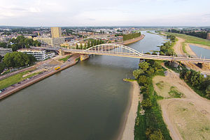
| The bridge seen from the Rijnkade (2012) | ||
The John Frost Bridge ( Dutch John Frostbrug , formerly Rijnbrug ) is a road bridge that crosses the Nederrijn , the northwest arm of the Rhine in the Rhine-Maas Delta , in the Dutch city of Arnhem .
The bridge was the subject of the 1944 Battle of Arnhem as part of Operation Market Garden . It was named in 1978 after the British Major General John Frost (1912-1993).
description
The 601 m long bridge connects the eastern edge of the old town of Arnhem with its southern district of Malburgen and leads the Nijmeegseweg over the Oranjewachtstraat, the quayside streets Nieuwe Kade and Rijnkade, the Nederrijn and its flood bed, in which a large pond was created. It has four lanes and a sidewalk and bike path on both sides. One lane is reserved for public buses. Staircases create the connection to the two banks.
The steel, riveted main bridge consists of a tied arch bridge with a span of 120 m and two 50 m wide girder bridges. The two arches have a hollow cross-section, are 17.5 m high and stiffened by a K-shaped wind bracing. Its two stiffening girders are 3.4 to 4 m high, hollow boxes with savings openings on the underside , which pass through the main opening and the two secondary openings . Further longitudinal members and a K-shaped wind bracing form the basis for the deck slab. The two 4 m wide sidewalks and cycle paths are mounted on brackets outside the arches. Overall, the bridge is 23.2 m wide.
The southern foreland bridge is a steel girder bridge with a construction similar to the main bridge, while the northern foreland bridge is a concrete girder bridge.
history
The first bridge in Arnhem was the Arnhem Ship Bridge, built in 1603 , which - many times renewed - remained in operation until 1935.
The Rijnbrug was built between 1932 and 1935 as part of the first Rijkswegenplan (1927) to modernize the national infrastructure. It was the first fixed Rhine bridge in Arnhem and the first tied arch bridge in the Netherlands. It was designed by Willem JH Harmsen, the first director of the Rijkswaterstaat Bruggenbureau , and the architect Albert Johan van der Steur. It had essentially the same dimensions as today's bridge, but a wooden deck. The bridge was inaugurated on June 16, 1936 by Queen Wilhelmina , on the same day as the Waal Bridge in Nijmegen .
After its completion, it was Arnhem's most important link over the Nederrijn and enabled the major city extensions south of the river.
During the Second World War , the German invasion of the Netherlands, Belgium and Luxembourg began on May 10, 1940 . In order to stop the German advance, engineers from Rijkswaterstaat blew up the bridges in Arnhem and Nijmegen. The Rijnbrug was soon replaced by a pontoon bridge, while its repair lasted until August 1944.
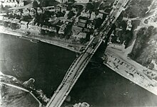
On September 17, 1944 began Operation Market Garden , in the paratrooper units of the Allies the German Siegfried Line bypass and to, among other things Rijnbrug should conquer. A British unit under Lieutenant Colonel John Frost managed to occupy the north end of the bridge, but was fired at from both sides by German troops. After extremely fierce and costly fighting, the British had to give up the fight on September 21 due to a lack of ammunition and supplies. The Allies did not succeed in further fighting to capture the bridge. To prevent the Germans from strengthening their positions south of the bridge, it was bombed on October 7, 1944. The Germans blew up the remainder of the bridge in February 1945.
After the war, a Bailey Bridge was first built next to the destroyed bridge, but it was too low for ships. After the rubble had been cleared from the river, it was installed on the remaining pillars and opened on February 6, 1946.
The new building was opened on May 9, 1950 by Willem JH Harmsen, who in the meantime had risen to become General Director of Rijkswaterstaat. At that time, Rijkswaterstaat still adhered to the tradition of naming bridges after the river crossed. In 1951, John Frost unveiled a plaque donated by the Province of Gelderland in the northern abutment. In 1978 the bridge was renamed John Frostbrug .
See also
Web links
- John Frost Bridge In: liberationroute.de . Liberation Route Europe Foundation
- John Frostbrug . In: cultureelerfgoed.nl . Rijksdienst voor het Cultureel Erfgoed (Dutch)
Individual evidence
The article is largely based on John Frostbrug . In: cultureelerfgoed.nl . Rijksdienst voor het Cultureel Erfgoed
|
The next bridge upriver: Nederrijn : Andrei-Sakharov Bridge |
Bridges over the Rhine |
The next bridge downstream: Nederrijn : Nelson Mandela Bridge |


