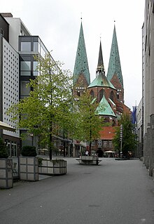
Schrangen

The Schrangen is a street in Lübeck's old town .
location
The approximately 100 meter long Schrangen is located in the center of the city in the north-west corner of the Johannis Quartier . It begins in the Breite Straße opposite the office building and leads down as a square-like, wide connection to the parallel Königstraße .
history
Since the 13th century, the butcher's stalls ( Schrangen in Low German , literally originally barriers in the old sense of tables or counters ) have been in a square on Breite Straße, opposite the current office building. This place formed the area actually called Schrangen. Two narrow streets formed the entrance from Königstraße, of which the northern one was first mentioned in 1293 with the Latin name macella carnificum ( butcher's meat market). In 1457 the Low German name was Vleschschrangen (meat stalls ), 1472 Küterstrate after the term Küter for butcher. In 1587 the variant Kutterstraße is occupied, in 1700 the version of Köterstraße, which has a twisting effect, is used . The southern street with the Latin name platea praeconum ( court usher street) was first mentioned in 1294. The name referred to the Frohnerei located here , which was the official residence of the town bailiffs and served as a place of execution for sentences imposed by the courts and as a prison . The Low German names Boddelstrate (1458) and Bodelstrate (1471), both of which mean Büttelstraße , also refer to this. The merrymaking was stopped in 1840.
Until 1845, the Lübeck butchers were legally required to sell meat exclusively on the Schrangen. After this regulation was repealed, the booths lost their function, as the butchers now preferred to offer their goods in their houses. The stalls were demolished and the space that had now become free was planted with trees. The name Schrangen was increasingly transferred to the streets leading up from Königstraße, and this development was confirmed in 1884 when the northern street was officially given the name Alter Schrangen , which had already been used for a long time , and the southern one became the Kleiner Schrangen . The square that represented the actual Schrangen had already been built on with a newly built syringe house in 1852 and had completely disappeared.
In 1928 and 1929 the buildings between the old and the small Schrangen were demolished along their entire length between Breiter Straße and Königstraße and a new, square-like street was created. The two alleys formally ceased to exist in 1931 and merged into the newly created cupboards .
architecture
The Schrangen is dominated today by the two newly constructed 1993-1997 Karstadt - Kaufhausbauten which occupy the entire north side and the south side of King street. Historical buildings no longer exist, since the previously preserved medieval arcade houses on the south side were demolished in 1960 in favor of a very unadorned new department store building .
The future design of the less attractive asphalt surface of the Schrangen has been controversial for years. For a long time the city of Lübeck had no concept whatsoever; the current face of the street with trees in planters and a catering establishment built as a permanent provisional facility reflects this through its makeshift style. While citizen surveys always showed that the public favored permanent planting and design as an attractive place to stay, architects and town planners also regularly rejected these ideas as not suitable for the formation of inner-city spaces. Most recently, the city administration decided to build a massive restaurant building, which met with considerable criticism, as this would impair the view of St. Mary's Church . These plans are now obsolete, among other things because it turned out that there are no restaurateurs who would be interested in using the building. The future of the Schrangen is therefore still open.
literature
- W. Brehmer : The street names in the city of Lübeck and its suburbs. HG Rathgens, Lübeck 1889.
- Max Hoffmann: The streets of the city of Lübeck. In: Journal of the Association for Lübeck History and Archeology. Jg. 11, 1909, ISSN 0083-5609 , pp. 215-292 (also special print: 1909).
- The jurisprudence of the Higher Appeal Court of the four free cities in Germany in civil cases from Lübeck. Volume 1: 1848/55. Verlag Hermann Gesenius, Bremen 1866, ZDB -ID 513049-9 .
Web links
Coordinates: 53 ° 52 ′ 3.3 " N , 10 ° 41 ′ 12.6" E


