Black Forest (Frankenblick)
|
Black Forest
Community Frankenblick
Coordinates: 50 ° 23 ′ 41 ″ N , 11 ° 7 ′ 32 ″ E
|
|
|---|---|
| Height : | 500 m |
| Postal code : | 96529 |
| Area code : | 03675 |
|
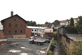
View from the Schwarzwälder Straße to the Effelder
|
|
Black Forest , formerly also Schwartzwald , is a residential area in Mengersgereuth-Hammern , part of the municipality of Frankenblick in the district of Sonneberg in Thuringia .
location
The area is located northwest of Sonneberg between Mengersgereuth and Forschengereuth on a connecting road ( L 2657 ). The Effelder stream flows through the location . The Große Mühlberg (716 m) and the Oberschaar (724 m) rise to the north of the village .
history
In 1408 the foothills village was first mentioned in a document.
traffic
The Eisfeld – Sonneberg railway runs through the village , the next stops are the Forschengereuth station, which was renamed Mengersgereuth-Hammern Ost station in 1935 , and the Mengersgereuth-Hammern station. The L 2657 connects the place with the south tangent B 89 , which leads from there to Sonneberg in the south and Schalkau in the west.
Individual evidence
- ^ Wolfgang Kahl : First mention of Thuringian towns and villages. A manual. 5th, improved and considerably enlarged edition. Rockstuhl, Bad Langensalza 2010, ISBN 978-3-86777-202-0 , p. 258.
