Sender Eys
|
Sender Eys
Zendmast Eys
|
||
|---|---|---|
| Basic data | ||
| Place: | Gulpen-Wittem - Eys | |
| Province: | Limburg | |
| Country: | Netherlands | |
| Altitude : | 190 m NAP | |
| Coordinates: 50 ° 49 ′ 55.2 " N , 5 ° 55 ′ 32.7" E | ||
| Use: | Broadcasting station | |
| Accessibility: | Transmission mast not open to the public | |
| Mast data | ||
| Construction time : | 1972 | |
| Building material : | steel | |
| Operating time: | since 1972 | |
| Data on the transmission system | ||
| Waveband : | FM transmitter | |
| Radio : | VHF broadcasting | |
| Position map | ||
|
|
||
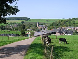
The Eys transmitter is the highest transmitter in the Netherlands . It is located on a hill north of the village of Eys in the Dutch province of Limburg . A guyed, 94-meter-high tubular mast, which was erected in 1972, serves as the antenna carrier.
Although the coverage area is in Limburg, the programs can also be received in neighboring regions of Belgium and Germany, including Aachen , due to the height of the location and the proximity to the state border .
Frequencies and Programs
Analog radio (VHF)
|
Frequency (MHz) |
program | RDS PS | RDS PI | Regionalization |
ERP (kW) |
Antenna pattern round (ND) / directional (D) |
Polarization horizontal (H) / vertical (V) |
|---|---|---|---|---|---|---|---|
| 91.5 | BNR Nieuwsradio | __BNR___ | 83D1 | - | 10.7 | D (300 ° -330 °) | V |
| 97.2 | NPO Radio 2 | RADIO_2_ | 8202 | - | 13 | D (300 ° -330 °) | V |
| 98.1 | RADIONL | RADIONL_ | 8421 | Limburg South | 2.3 | D (250 ° -350 °) | V |
Analog television (PAL)
Before the switch to DVB-T, the broadcasting location was still used for analog television:
| channel |
Frequency (MHz) |
program |
ERP (kW) |
Transmission diagram round (ND) / directional (D) |
Polarization horizontal (H) / vertical (V) |
|---|---|---|---|---|---|
| 51 | 711.25 | NPO 1 | 1 | ND | H |
| 54 | 735.25 | NPO 2 | 1 | ND | H |
| 48 | 687.25 | NPO 3 | 1 | ND | H |


