Set Tai
| Set Tai | ||
|---|---|---|
|
|
||
| Coordinates | 14 ° 0 ′ N , 105 ° 57 ′ E | |
| Basic data | ||
| Country | Laos | |
| Champasak | ||
| ISO 3166-2 | LA-CH | |
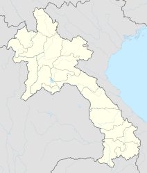
Ban Set Tai (also Sét Tai ) is a village in the extreme south of Laos in the Khong district of Champasak province . The place is located near the eastern bank of the Mekong in the Si Phan Don area ( four thousand islands ) near the island of Don Tao .
The national road 13 runs through the place. The small fishing village of Ban Sene Hom is located directly south of Set Tai on the banks of the Mekong . Other neighboring towns are Ban Thakho and the border town of Veun Kham in the southeast, Nakasong and Khinak in the northwest and the inhabited islands of Don Det and Don Khon in the southwest.
