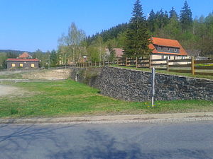
Silberhütter Pochwerksteich
| Silberhütter Pochwerksteich | |||||||||
|---|---|---|---|---|---|---|---|---|---|
| Today only the dam is visible. | |||||||||
|
|||||||||
|
|
|||||||||
| Coordinates | 51 ° 37 '43 " N , 11 ° 5' 33" E | ||||||||
| Data on the structure | |||||||||
| Construction time: | before 1779 | ||||||||
| Height above the river bed : | approx. 355 m above sea level | ||||||||
| Data on the reservoir | |||||||||
| Storage space | 4th 000 m³ | ||||||||
| Particularities: |
Filled in in 1955 |
||||||||
The Silberhütter Pochwerksteich was a reservoir in the middle Lower Harz near Silberhütte , Saxony-Anhalt . The Teufelsgrundbach was dammed . The pond is part of the Unterharzer pond and ditch system .
history
The construction time of the pond is unknown. The pond was created with a storage space of 0.4 million m³ below the Fürstenteich , just before the confluence of the Teufelsgrundbach in the Selke . The first written mention of it comes from the year 1779. Unlike the other three ponds located on the Teufelsgrundbach ( Silberhütter Klär-Teich , Fürstenteich and Teufelsteich ), the Silberhütter Pochwerksteich was not an artificial pond , but served as an engine pond for the Pochwerk in Silberhütte.
In 1955 the pond was filled in. The reasons for this are unknown.
See also:
swell
- Development and current function of systems of historical mining water management in the Lower Harz . In: Wilfried Strenz, Working Group Historical Geography of the Geographical Society of the GDR (ed.): Historical-geographical research in the GDR . Hermann Haack Geographisch-Kartographische Anstalt, Gotha 1986, ISBN 3-7301-0803-4 .
- Saxony-Anhalt viewer, official topographic map, TK 1:25 000 color

