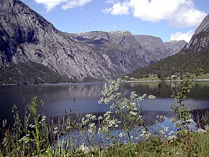
Simadalsfjord
| Simadalsfjord | ||
|---|---|---|
|
Simadalsfjord |
||
| Waters | Eidfjord | |
| Land mass | Scandinavian peninsula | |
| Geographical location | 60 ° 29 '14 " N , 7 ° 5' 33" E | |
|
|
||
The Simadalsfjord is the innermost section of the Eidfjord in the municipality of the same name Eidfjord in Vestland and thus also the last area of the Hardangerfjord .
It is four kilometers long and extends from the Sima power station at its beginning at the end of the Simadalen westwards to about the imaginary line from Eikenes to Blurnes on the south side, where it is about 800 m wide. On the north side are the old Kjeåsen farm and the 1621 m high Fjell Onen. Fylkesvei 103 runs on the south side.
Cod , mackerel , haddock , coalfish , whiting and pollack can be found in the waters .

