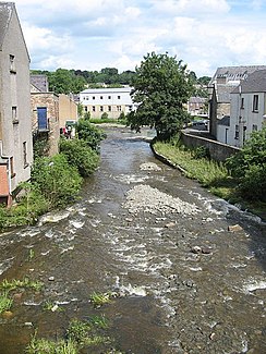
Slitrig Water
| Slitrig Water | ||
|
The Slitrig Water in Hawick |
||
| Data | ||
| location | Scottish Borders , Scotland | |
| River system | tweed | |
| Drain over | Teviot → Tweed | |
| source | Confluence of two streams in Wauchope Forest 55 ° 19 ′ 41 ″ N , 2 ° 44 ′ 15 ″ W |
|
| muzzle | in Hawick in the Teviot coordinates: 55 ° 25 ′ 20 " N , 2 ° 47 ′ 22" W 55 ° 25 ′ 20 " N , 2 ° 47 ′ 22" W
|
|
| length | 17.5 km | |
The Slitrig Water is a river in the Scottish Borders Scottish Council Area .
course
The river is created by the confluence of the Leap Burn and Flosh Burn on the western edge of the Wauchope Forest . Historically, it flowed through the county of Roxburghshire , which has become part of the Scottish Borders. After a run of 17.5 kilometers, the Slitrig Water in the center of Hawick pours into the Teviot from the right .
The Slitrig Water follows a north-westerly to northerly direction. It has a high mean gradient, which results in its high flow velocity. Its valley is often narrow and steep, but the Slitrig Water also has flat shorelines. His bed is stony.
Surroundings
The Slitrig Water flows through a sparsely populated region of the Scottish Borders. There are no significant settlements along its course. With its estuary Hawick it reaches the only town along the course. The B6399 follows Slitrig Water over long distances and crosses it three times. The Waverley Line also follows the course of the Slitrig Waters.
On the hilltops along its valley, the remains of three hill forts , Denholm Hill Fort , Blakebillend Fort and Pleaknowe Fort , have been uncovered, which prove historical settlement. In a meander of the Slitrig Waters lies the manor Stobs Castle . An access road to the manor spans the Slitrig Water with a neo-Gothic bridge. Along with the Kirkwynd Bridge and the Crowbyres Bridge , it is one of three listed bridges over the Slitrig Water.
Due to the availability of hydropower through Teviot and Slitrig Water, Hawick developed into one of the most important textile locations in Scotland with one of the highest per capita incomes. The Tower Mill has been preserved today. Unique in Scotland, it stands on a bridge over Slitrig Water. It also has the largest waterwheel in southern Scotland.
Individual evidence
- ↑ a b Information in the Gazetteer for Scotland
- ↑ a b c Map of the Ordnance Survey
- ↑ a b Slitrig Water : FH Groome (ed.): Ordnance Gazetteer of Scotland: A Survey of Scottish Topography, Statistical, Biographical and Historical , Publishing Works Grange, Edinburgh, from 1882 to 1885.
- ↑ Historic Environment Scotland - entry . In: Historic Scotland .
- ↑ Historic Environment Scotland - entry . In: Historic Scotland .
- ↑ Historic Environment Scotland - entry . In: Historic Scotland .
- ↑ Entry on Stobs Castle in Canmore, the database of Historic Environment Scotland (English)
- ↑ Historic Environment Scotland - entry . In: Historic Scotland .
- ↑ Historic Environment Scotland - entry . In: Historic Scotland .
- ↑ Historic Environment Scotland - entry . In: Historic Scotland .
- ↑ Historic Environment Scotland - entry . In: Historic Scotland .
