Smbataberd
Smbataberd ( Armenian Սմբատաբերդ , "Castle of Smbat") is the ruin of a medieval fortress in the southern Armenian province of Vajoz Dzor above the village of Yeghegis , which was expanded in the 10th century and until its presumed conquest by the Mongols in the 13th century Was owned by the Orbelian princely family.
location
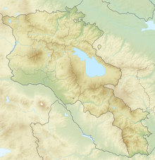
Coordinates: 39 ° 52 ′ 18.2 ″ N , 45 ° 20 ′ 17.2 ″ E
Smbataberd can be reached via the M10 trunk road , which branches off the M2 between Areni and Yeghegnadsor near Getap and leads north over the Selim Pass to Lake Sevan . After ten kilometers in the village of Schatin, a side road turns northeast to the village of Jeghegis in the valley of the river of the same name, six kilometers away . At the entrance sign, a path about one kilometer long begins, which climbs the fortress hill on a direct route from the southeast side.
The fortress is more convenient to reach from the opposite north-western side of the hill. Two kilometers after Schatin, a side road leaves the Jeghegis valley and follows a tributary in a side valley. After one kilometer, it crosses the elongated village of Artabuynk and ends after a few kilometers in the hamlet of Horbategh at the end of the valley. About a kilometer behind the last houses in Artabuynk, a road begins to the right of the road at a ford and a footbridge over the stream. The road initially climbs a good kilometer in an easterly direction until it forks at a level point. After another kilometer towards the southwest, the path leads up to the fortress at an altitude of 1925 meters, in the other direction it reaches the ruins of the former Tsaghats Kar monastery, which is a little further away, at an altitude of 2052 meters. From there, the fortress can be seen in the distance. A two-kilometer long footpath over the ridge between the monastery and the fortress shortens the road.
history
There may have been a fortress on this site as early as the 5th century. The ancient Greek historian Strabo mentions the name Symbace for a place or an area under Armenian rule that was in the vicinity of the Atropacene (Armenian Atrapatakan) region, which was occupied by the Romans. The fortress is mentioned in connection with the Battle of Avarayr of 451, during which Armenian insurgents fought against the Sassanids for the free practice of their Christian religion. In addition to Avarayr, battles took place in the Vajoz Dzor region, one of them near Smbataberd.
The original name and later namesake of the fortress are unclear. A 13th-century prince Smbat from the Orbelian dynasty, who is buried in Jeghegis, or another noble named Smbat Orbelian, whose grave is in the Noravank monastery and who had the fortress rebuilt, are possible. However, the local population probably named the fortress after Prince Smbat of the Sjunik family, who lived in the 10th century. As the historian Bishop Stepanos Orbelian reports in the 13th century, Amir Yusuf, ruler of Atrapatakan and opponent of the Armenian Bagratids , ordered the invasion of Sjunik in 922 . In order to protect Jeghegis from the attackers, Prince Smbat had a defensive structure built, which they were unable to defeat and would have withdrawn. With just as wise foresight, Smbat had his seat of rulership fortified in Jeghegik (today Jeghegnadsor) and guarded by a strong army. Stepanos Orbelian describes Kapuyt Berd ("Blue Castle") as one of the most powerful fortresses of Vajoz Dzor . This name is localized with Smbataberd.
There is no spring in the immediate vicinity. Legend has it that the Seljuks conquered the fortress, which was considered impregnable, in the 11th century by bringing a thirsty horse to track down the secret water supply. This is how they discovered the underground aqueduct that ran two kilometers from Tsaghats Kar monastery to Smbataberd. According to other reports, the Armenians were able to hold the fortress until the 13th century when it was stormed by the Mongols.
After the mass deportation of the Armenian population to Isfahan in 1604 by the Persian Shah Abbas I and subsequent wars between the Ottomans and the Persian Safavids , many villages in the region were deserted. The fortress fell into disrepair and was also abandoned.
Fortress
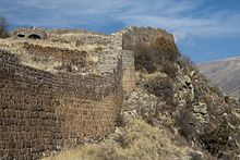
The fortress occupies a sloping, 6.5 hectare triangular area at the southern tip of a range of hills that slopes steeply to the southeast to the valley of the Jeghegis and to the northwest to the valley of Artabuynk. The main gate is on the north side, there was a side entrance in the west and a "king's gate" in the east. The enclosing walls were two to three meters thick, eight to ten meters high and were reinforced by several round towers . In particular, the mighty walls that have been preserved over the eastern precipice in connection with the strategically favorable location make it clear that the fortress must have been difficult to conquer.
Smbataberd provided living space for hundreds of people who could withdraw here. Only small remains of the walls of the buildings inside have survived. In the north, the remains of the walls of the soldiers' quarters and a water basin have been preserved. The highest part of the area is taken up by the round walls of the citadel in the southwest. A large part of the site has not yet been excavated, but the defensive walls have been partially restored. Footpaths open up the facility for tourism.
The watchtowers that once stood on the surrounding wall have now disappeared. The outdoor area included several observation towers, one of which was a kilometer east and another 800 meters west on another hill. Remnants of the clay pipes through which water was drawn from Tsaghats Kar are displayed in the Yeghegnadzor Regional Museum.
Web links
- Rick Ney: Vayot's Dzor. TourArmenia, 2009, p. 20
- Smbataberd. Armenian Heritage
- Smbataberd Fortress . Armeniapedia
- Smbataberd . greatyerevan.com
- Smbataberd Fortress . findarmenia.com
See also
Individual evidence
- ↑ Strabo, Geography 11.13.4.
- ^ Smbataberd 1: History. Map legend . Armenian Heritage
- ↑ Smbataberd 2: Lower Complex. Gates. Map legend. Armenian Heritage


