Socorro (island)
| Socorro | ||
|---|---|---|
| Socorro seen from the sea | ||
| Waters | Pacific Ocean | |
| Archipelago | Revillagigedo Islands | |
| Geographical location | 18 ° 48 ′ N , 110 ° 59 ′ W | |
|
|
||
| length | 16.8 km | |
| width | 15.6 km | |
| surface | 131.861 km² | |
| Highest elevation |
Monte Evermann 1050 m |
|
| Residents | 45 <1 inh / km² |
|
| main place | Bahia Lozano | |
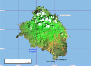
| Map of Socorro | ||
Socorro ( Spanish Isla Socorro or Isla Santo Tomás ; outdated: Isla Anublada ) is a volcanic island in the eastern Pacific Ocean , about 440 km south of the southern tip of Lower California . Politically, the island belongs to the Mexican state of Colima , from whose coast it is a good 700 km away.
Geography and geology
Socorro is by far the largest of the Revillagigedo Islands and is 51.5 km from the neighboring island of San Benedicto in the east and 107 km from Roca Partida in the west. It is 314 km to Clarión , the westernmost island of the archipelago .
Socorro is 16.8 km long, up to 15.6 km wide and has an area of almost 132 km². It represents the part of a massive shield volcano located above the sea , with Monte Evermann reaching a height of 1050 m above sea level. The volcano is named after Barton Warren Evermann , the director of the California Academy of Sciences , who promoted scientific exploration of the island at the beginning of the 20th century. The island rises steeply from the Pacific, its landscape is characterized by a multitude of craters and gorges, some of which are filled with solidified lava . The last eruptions occurred in 1905 and 1951. In 1993/94 there was an underwater eruption three kilometers west of the coast.
history
As the first of the Revillagigedo Islands, Socorro was discovered on December 21, 1533 by the Spanish explorer Hernando de Grijalva on board the San Lázaro and named Isla Santo Tomás . In 1541 it was first mapped by Domingo del Castillo . In search of gold, the island was entered by Martín Yañez de Armida in 1608 and renamed Socorro (German: Help, Beistand).
In the 19th century in particular, the island was visited by numerous researchers, including Alexander von Humboldt in 1811 , Benjamin Norell in 1825 and Edward Belcher in 1839 . In 1855 Socorro was visited by the American ornithologist Andrew Jackson Grayson , who discovered numerous bird species and systematically recorded them.
In 1957 a Mexican naval base was built not far from the southern tip, on Cabo Regla . About 250 soldiers and their relatives lived in the neighboring village; otherwise the island is uninhabited. Since 1994 Socorro has been part of the Reserva de la Biosfera "Archipiélago de Revillagigedo" biosphere reserve .
In September 1997, the island was hit by Hurricane Linda , the strongest cyclone ever observed in the eastern Pacific.
Flora and fauna
Socorro is the richest in flora and fauna of the four Revillagigedo Islands. Only low-growing plants grow on the stony, dry surface, and there are no fewer than 41 endemic plant species. The island is famous for its endemic bird species. Mention may be made: The Socorrospottdrossel ( Mimodes graysoni ), the only species of its genus, of which there are only less than 400 individuals, the Socorrosittich ( Aratinga brevipes ), the Socorrozaunkönig ( Troglodytes sissonii ) and the domestic only Soccoro subspecies of Elfenkauzes ( Micrathene whitneyi graysoni ). The Socorrotaube ( Zenaida graysoni ) is extinct in the wild, but is bred in captivity. The Townsend Shearwater ( Puffinus auricularis ), which is endemic to the archipelago, is also threatened .
The unique flora and fauna is endangered by neobiota . In 1869 sheep were introduced to Socorro; the residents of the naval base added other pets such as cats and pigs. Efforts are being made to drastically reduce the numbers of feral domestic animals, but this will probably take many years to come.
Web links
- Socorro in the Global Volcanism Program of the Smithsonian Institution (English)
- CONANP Reserva de la Biosfera "Archipiélago de Revillagigedo" ( Memento of January 24, 2008 in the Internet Archive ) (Spanish)
- Instituto Nacional de Ecología - Reserva de la Biosfera Archipiélago de Revillagigedo (Spanish)
Individual evidence
- ↑ Superficie Continental e Insular del Territorio Nacional ( Memento of the original from July 22, 2011 in the Internet Archive ) Info: The archive link was inserted automatically and has not yet been checked. Please check the original and archive link according to the instructions and then remove this notice. (Spanish)


