Songnim
| Songnim-si | |||
|---|---|---|---|
| Korean alphabet : | 송림 시 | ||
| Chinese characters : | 松林 市 | ||
| Revised Romanization : | Songnim-si | ||
| McCune-Reischauer : | Songnim-si | ||
| Basic data | |||
| Province : | Hwanghae-pukto | ||
| Coordinates : | 38 ° 44 ′ N , 125 ° 38 ′ E | ||
| Residents: | 128,831 (as of 2008) | ||
| Structure: | 1 ŭp, 5 rodongjagu, 15 ri | ||
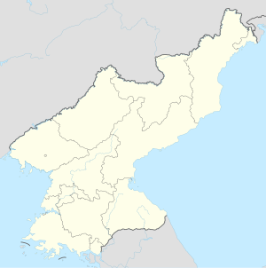
| map | |||
|
|||
Songnim ( kor. 송림 ) is a port city in North Korea with 128,831 inhabitants. It is located in Hwanghae-pukto Province on the Taedong River and is a center of the steel industry .
history
Until 1910 the place was called Solme ( 솔메 ) and was a poor village.
From 1910 to 1945 Korea was a colony of Japan . During this time the place was called Kenjiho ( Japanese 兼 二 浦 ; 겸이 포 , Kyŏmip'o ). In 1916 an iron foundry was founded . With the developing steel industry, Kenjiho quickly grew into a city.
In 1947 the place was renamed to its current name.
During the Korean War , Songnim was completely destroyed by bombing.
Web links
- JoongAng Ilbo : 송림 시 (松林 市) SONGRIMSI from 1997 (Korean)
- Rainer Dormels: Songrim - the city of the Hwanghae Iron and Steel Complex , 2014 (PDF; 527 kB)
Individual evidence
- ↑ 2008 Census of Population of DPR Korea (PDF file; 1.4 MB), Central Bureau of Statistics , p. 21 Songrim City (English).
- ↑ a b c Songnim in the Encyclopædia Britannica , accessed on April 25, 2013 (English).

