Taedong gang
| Taedong gang | ||
|
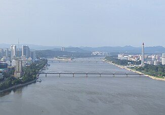
Taedong in Pyongyang |
||
| Data | ||
| location | North Korea | |
| River system | Taedong gang | |
| source |
Nangnim Mountains 40 ° 53 ′ 7 ″ N , 126 ° 57 ′ 30 ″ E |
|
| muzzle | at Namp'o in Korea Bay Coordinates: 38 ° 41 ′ 31 ″ N , 125 ° 12 ′ 31 ″ E 38 ° 41 ′ 31 ″ N , 125 ° 12 ′ 31 ″ E |
|
| Mouth height |
0 m
|
|
| length | 439 km | |
| Catchment area | 20,344 km² | |
| Discharge at the Dokchon A Eo gauge : 3300 km² |
MQ 1965/1981 Mq 1965/1981 |
80 m³ / s 24.2 l / (s km²) |
| Discharge at the Mirim A Eo gauge: 12,175 km² |
MQ 1964/1982 Mq 1964/1982 |
267 m³ / s 21.9 l / (s km²) |
| Left tributaries | Nam-gang , Chaeryŏng-gang | |
| Right tributaries | Pothong gang | |
| Reservoirs flowed through | Nangnim Reservoir , Kumsong Reservoir | |
| Big cities | Tokchon , Sunch'ŏn , Pyongyang , Songnim , Namp'o | |
|
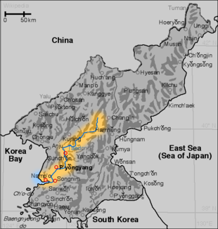
Course of the Taedong gang |
||
| Korean spelling | |
|---|---|
| Korean alphabet : | 대동강 |
| Hanja : | 大同 江 |
| Revised Romanization : | Daedong gang |
| McCune-Reischauer : | Taedong gang |
The Taedong is a river in North Korea .
It rises in the Nangnim Mountains in the Hamgyŏng-namdo province , flows in a south-westerly direction, with the tributary Pothong-gang through the capital Pyongyang and flows into the Yellow Sea at Namp'o . It is 439 kilometers long and navigable for 4,000 ton ships to Songnim , for 2,000 ton ships up to 65 kilometers below the source. Further up the river, it is mainly used for irrigation and energy generation. Important tributaries are Biryu-gang , Nam-gang and Chaeryŏng-gang . The two reservoirs Nangnim and Kumsong are located on the upper reaches .
Nyongwon hydroelectric power station
On October 5, 2005, the Nyongwon hydropower plant was opened on the upper reaches of the river. The large dam through a mountain valley is intended to protect the capital Pyongyang from flooding and contribute to the country's energy supply.
West Sea Dam
The Koreans call the Yellow Sea the West Sea . At the mouth of the Taedong in this sea near Namp'o, three army divisions built what was then the largest dam in the world between 1981 and 1986. The so-called West Sea Barrage consists of an eight-kilometer-long dam, three locks for ships up to 50,000 GRT , 36 sluices and an observation deck with a museum building in anchor shape.
The dam serves primarily as a watershed between sea and river water, as a fast road and rail link between the north and south banks of the Taedong, and as a physical barrier at the mouth of the river. It protects the region from possible flood disasters up to Pyongyang, makes shipping traffic independent of the strong tides and serves to ensure the availability of fresh water for industry and the region's drinking water supply. Two billion cubic meters of water are pumped each year. The dam is not used to generate electricity.
Before the dam was built, sea salt was extracted in salt pans upriver. These pans have largely been idle since the sea and river were separated.
Remarks
The station Taedonggang and taedonggang brewing company is named after the river and are in Pyongyang .
See also
Web links
- National Committee of DPR Korea for IHP UNESCO: Taedong River Basin (English; PDF; 8.4 MB)
Individual evidence
- ↑ UNESCO - Dokchon ( Memento of the original from March 4, 2016 in the Internet Archive ) Info: The archive link was inserted automatically and has not yet been checked. Please check the original and archive link according to the instructions and then remove this notice.
- ↑ UNESCO - Mirim ( Memento of the original from March 4, 2016 in the Internet Archive ) Info: The archive link was inserted automatically and has not yet been checked. Please check the original and archive link according to the instructions and then remove this notice.

