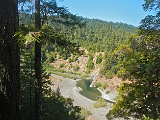
South Fork Eel River (California)
| South Fork Eel River | ||
|
River course in the catchment area of the Eel River |
||
| Data | ||
| Water code | US : 253918 | |
| location | California (USA) | |
| River system | Eel River | |
| Drain over | Eel River → Pacific Ocean | |
| source | in Mendocino County, 39 ° 36 ′ 46 " N , 123 ° 29 ′ 34" W. |
|
| muzzle | near Dyerville in the Eel River Coordinates: 40 ° 21 '21 " N , 123 ° 55' 10" W 40 ° 21 '21 " N , 123 ° 55' 10" W. |
|
| Mouth height |
33 m
|
|
| length | 169 km | |
| Catchment area | 1784 km² | |
| Discharge at the Miranda A Eo gauge : 1390 km² |
MQ 1940/2016 Mq 1940/2016 |
51 m³ / s 36.7 l / (s km²) |
| Communities | Benbow, Garberville, Leggett , Miranda, Myers Flat, Phillipsville, Redway, Weott | |
| National Wild and Scenic River | ||
|
South Fork Eel River in the Standish-Hickey SRA |
||
|
South Fork Eel River near Benbow |
||
The South Fork Eel River is the most important left tributary of the Eel River in the northwest of the US state California . The 169 km long river drains an area of 1784 km².
The South Fork Eel River has its source 9.3 km south of Laytonville in Mendocino County . It flows in a predominantly northerly direction through the California Coast Mountains . The US Highway 101 runs along the river. The South Fork Eel River finally flows into the Eel River at Dyerville in Humboldt County .
On January 19, 1981, a total of 640 km in the river system of the Eel River was designated as a National Wild and Scenic River . The section of the South Fork Eel River from its mouth to the confluence of Four Creek was placed under protection. Various salmon and salmonid species are found in the South Fork Eel River .
The Admiral Stanley State Recreation Area is close to the spring at Branscomb . A section of State Route 254 along the course of the river is called the Avenue of the Giants, a so-called scenic highway . At the upper reaches of Leggett is the Standish-Hickey State Recreation Area , further downstream is the Richardson Grove State Park . Not far from the estuary is the Humboldt Redwood State Park on the banks of the South Fork Eel River.
In the place Benbow on the middle reaches of the South Fork Eel River, the dam Benbow Dam was built in 1931 to generate electricity from hydropower. This created the 123 acre Benbow Lake . The dam was demolished again at the end of 2016. This means that the river is again accessible to migratory fish along the entire route .
Web links
Individual evidence
- ↑ a b c South Fork Eel River in the Geographic Names Information System of the United States Geological Survey
- ^ South Fork Eel River Watershed Studies (Humboldt and Mendocino Counties) . Calif. Dept. of Fish and Wildlife. Retrieved August 12, 2017.
- ↑ USGS 11476500 SF EEL R NR MIRANDA CA
- ↑ a b c National Wild and Scenic Rivers System: Eel River, California
- ↑ Benbow Dam demolition on schedule . Times Standard. 5th September 2016.
- ↑ Benbow Dam demolition began on Aug. 1 . Redwood Times. August 1, 2016.


