
Lock point Lavin

The blocking point Lavin (Army designation No. 1252) was a defensive position of the Swiss Army . It is located east and west of Lavin on the road from Davos over the Flüela Pass into the Lower Engadine .
The lock was built by civil companies in 1938–1943 and is considered a military historical monument of national importance. She belonged to the Border Brigade 12 .
history

Lavin was already fortified in World War I. During the Second World War , the village became a key point and developed as the first strong dam in the Lower Engadine. The four anti-tank obstacles east and west of the village were flanked by six infantry units / bunkers. There were also seven shelter caverns and, in the post-war period, modern shelters. The valley axis had to be closed and a hostile advance from the east into the Lower Engadine and further over the Vereina pass to Davos and Klosters had to be prevented or delayed.
The blocking point was recognised in July 1936 and in May 1938 the construction of road barricades and an infantry bunker began, three battle caverns followed in September 1940. The associated terrain armor obstacles (GPH T 4015) were created in 1942/43.
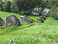
The powerful barrier was armed with eleven bunkered machine guns, an anti-tank cannon, two tank bunker cannons and an Lmg light machine gun. Lavin's houses were integrated into the barrier as an anti-tank barrier and position room. Open obstacle gaps were closed with terrain armor in the form of concrete bumps.
The main plant (Lavin left A 7609) with its elevated position could cover the entire barrier and its apron with fire. It was protected by the counterwork Valplan A 7611. The spacious tunnels would have allowed a subsequent expansion as an artillery plant in order to be able to work in the Lower Engadine. The bunker in the middle of the barrier (Lavin on the right A 7608) was able to strike an angle of 240 degrees with fire with its four machine guns. The southern flank of the valley had to be blocked with mobile infantry, which could be accommodated in three high-altitude shelters.
The 8.1 cm fortress mine launcher on Flüelastrasse near Susch / Murtèra, created in the 1970s, was placed in such a way that its fire could affect the Lavin and Crastatscha barriers .
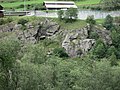
Systems of the blocking point
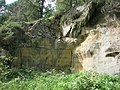
- Infantry rock plant Planturen right A 7605: 1 Pz BK, 1 Mg, 1 Lmg ⊙
- Infantry rock plant Planturen left A 7606: 1 Pz BK, 1 Mg ⊙
- Pranun rock A 7607: 1 Mg ⊙
- Infantry bunker Lavin right A 7608: 4 Mg ⊙
- Felswerk Lavin left A 7609: 1 Pak, 3 Mg ⊙
- Infantry bunker Valplan A 7611: 2 Mg ⊙
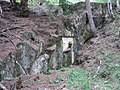
Main plant A 7609 entrance
A 7609 Mg 1
A 7609 Mg 2
A 7609 Pak

A 7609 Mg 3


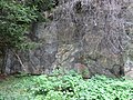
- GPH Northeast Church T 4015 ⊙
- GPH Northwest T 4015 ⊙
- GPH Südost Planturen T 4015 ⊙
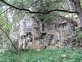
- GPH Southwest Erluns T 4015 ⊙
- Infantry bunker Susch West A 7616: two 8.1 cm fortress mine throwers ⊙

GPH T 4015 northeast
Rock plant Planturen on the left A 7606 with MG and tank bunker cannon

GPH T 4015 southwest
GPH Southwest on the Inn


literature
- Peter Baumgartner, Hans Stäbler: Fortified Graubünden. Wolves in sheep's clothing. Military History Foundation Graubünden, Chur 2006. New edition Verlag Desertina, Chur 2016, ISBN 978-3-85637-485-3 .
- Silvio Keller, Maurice Lovisa, Thomas Bitterli: Military monuments in the canton of Graubünden. Federal Department of Defense, Civil Protection and Sport (Ed.), Bern 2003.
Web links
Individual evidence
- ^ Silvio Keller, Maurice Lovisa, Thomas Bitterli: Military monuments in the canton of Graubünden. Federal Department of Defense, Civil Protection and Sport (Ed.), Bern 2003
- ↑ Crestawald: Lavin Lock Point
- ↑ Oberland Fortress: Lavin Lock Point ( Memento from August 24, 2017 in the Internet Archive )
- ↑ Fortified Graubünden 1941
Coordinates: 46 ° 46 '1.6 " N , 10 ° 7' 5.7" E ; CH1903: 804,648 / 183,043