
Jump (Schmiech)
| Jump | ||
 The spring pot of the spring |
||
| Data | ||
| location | Baden-Wuerttemberg , Germany | |
| River system | Danube | |
| Drain over | Schmiech → Danube → Black Sea | |
| source | Spring spring in Allmendingen 48 ° 20 ′ 6 ″ N , 9 ° 43 ′ 31 ″ E |
|
| Source height | approx. 520 m above sea level NN | |
| Spring discharge |
MNQ MQ MHQ |
58 l / s 390 l / s 1 m³ / s |
| muzzle | In the Schmiech coordinates: 48 ° 20 ′ 0 ″ N , 9 ° 43 ′ 35 ″ E 48 ° 20 ′ 0 ″ N , 9 ° 43 ′ 35 ″ E
|
|
| length | approx. 200 m | |
The Springe is a 200 m long left tributary of the Schmiech in Allmendingen in Baden-Württemberg .
geography
Spring spring
The Springequelle (officially: Quelle der Springe) is located at the northern exit of Großallmendingen , directly on the federal road 492 . It pours 58 to over 1000 liters per second (average discharge 390 l / s). The spring pot of the karst spring was framed with a concrete stone wall in an oval basin. The bottom of the approximately 25 m long pond was filled with white jura gravel. Some of the water comes from the Schmiech infiltration points.
course
The Springe flowing out of the karst spring flows in a southerly direction and after 200 meters flows into the Kleine Schmiech, a branch of the Schmiech .
See also
Web links

Exit point of the spring spring
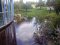
The jump between the source and the mouth

Mouth of the Springe (right) into the Kleine Schmiech (left)


