Staufen (southern Black Forest)
|
Staufen
Grafenhausen district
|
|
|---|---|
| Coordinates: 47 ° 45 ′ 23 " N , 8 ° 12 ′ 40" E | |
| Area : | 4.39 km² |
| Residents : | 130 |
| Population density : | 30 inhabitants / km² |
| Incorporation : | 4th January 1974 |
| Postal code : | 79865 |
| Area code : | 07748 |
|
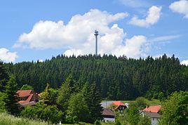
View of Staufen and Staufenkopf
|
|
Staufen is part of the Grafenhausen community in the Waldshut district in the southern Black Forest .
Staufen, Bulgenbach and the Heidenmühle and Klausenmühle houses in the Mettmatal formed an independent municipality until they were incorporated on April 1, 1974. The coat of arms of Staufen and Bulgenbach shows the soaring stag of the St. Blasien monastery and a bundschuh as a reference to Hans Müller von Bulgenbach . The district of Staufen is located on the eastern slope of the 1035 m high Staufenkopf . Together with Bulgenbach, it has around 130 inhabitants and covers an area of 439 ha.

