Steddorf
|
Steddorf
municipality Heeslingen
Coordinates: 53 ° 20 ′ 47 " N , 9 ° 23 ′ 59" E
|
||
|---|---|---|
| Height : | 26 (25-33) m | |
| Incorporation : | March 1, 1974 | |
| Postal code : | 27404 | |
| Area code : | 04287 | |
|
Location of Steddorf in Lower Saxony |
||
The village of Steddorf ( Low German Steddbod ) is a district of the Lower Saxon community of Heeslingen in the Rotenburg (Wümme) district and is located near the village of Heeslingen, to whose Börde it also belongs. Topographically, Steddorf can be classified almost exactly between Hamburg and Bremen .
Like many villages in the Geest lowlands, Steddorf is a relatively elongated place, that is, there are few side roads and mostly everything is located on a main road. The area is rural, as a large part of the area of Steddorf is cultivated by agricultural businesses. Primarily these are pig and dairy farms.
On March 1, 1974, Steddorf was incorporated into the community of Heeslingen.
The village community is determined by the sports club Teutonia Steddorf , the volunteer fire brigade , the playing group, the inn, an agricultural machinery company and the aforementioned farms.
The brooks Knüllbach and Hagenbeck flow through Steddorf and later unite to form the floodplain.
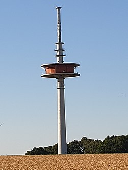
The most striking feature is the terrain between Steddorf and SELLHORN located 134 meters high telecommunications tower at 53 ° 21 '9 " N , 9 ° 25' 1" O . It is a standardized telecommunications tower of the former Deutsche Bundespost, a so-called type tower (FMT 2/73). Nesting aids for peregrine falcons are also installed on this. It also resembles the Wahnbek telecommunications tower .
Sellhorn, Flachsberg and Brake belong to Steddorf.
Oddities
Although Steddorf administratively belongs to Heeslingen, the place has its own telephone area code together with some neighboring communities. Heeslingen, in turn, has the area code of Zeven. This sometimes makes the search in the phone book a bit confusing for the uninitiated.
Individual evidence
- ^ Federal Statistical Office (ed.): Historical municipality directory for the Federal Republic of Germany. Name, border and key number changes in municipalities, counties and administrative districts from May 27, 1970 to December 31, 1982 . W. Kohlhammer GmbH, Stuttgart and Mainz 1983, ISBN 3-17-003263-1 , p. 241 .


