
Steebschacht
| Steebschacht
|
||
|---|---|---|
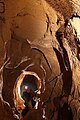
 The entrance to the Steebschacht |
||
| Location: | Swabian Alb . | |
| Height : | 703 m above sea level NN | |
|
Geographic location: |
48 ° 26 '14.9 " N , 9 ° 44' 42.6" E | |
|
||
| Cadastral number: | 7524/120 | |
| Type: | air-filled shaft cave | |
| Discovery: | 1680 | |
| Overall length: | 651 m | |
| Level difference: | 154 m | |
| Particularities: | Probably part of the blue cave system | |
| Website: | www.hoehlenverein-blaubeuren.de | |

The Steebschacht is a shaft cave near Wennenden ( Seißen , Blaubeuren ) on the Swabian Alb . Due to its location in the main fracture direction only about 1 km away from the current end of the blue cave system, it is likely to belong to it. Markers from dyeing experiments could be detected in the blue pot .
As of July 2020, the Steebschacht is the deepest cave in the Swabian Alb at −154 m.
Research history
The Steebschacht was first mentioned as a large sinkhole by the Laichingen pastor Johannes Mayer as a triple earth break "five hundred paces from the Wennenden farm towards Blaubeuren" in 1680. In 1964, as part of the planning for a sewage treatment plant, it was planned to include the sinkhole as a rainwater overflow. However, the project was not implemented due to the changed legal situation.
Instead, the sinkhole was dredged and a concrete foundation was placed at a depth of 16 m, on which concrete rings were placed up to the surface. The sinkhole was filled at ground level. In 2009, the Blaubeuren cave association obtained an excavation permit and opened the shaft that had been closed for decades.
After lengthy renovation work on the shaft foundation and unstable rocks in the upper part of the cave, the exploration could start in 2012. Since the found depth of about 40 m still left a lot of air down to the karst water level , an excavation was started at the deepest point.
The excavation activities have been intensified over the course of time, and in 2016 the construction of a cable car started in order to be able to transport the excavation material more efficiently to the deposition point. The cave also got a 3 × 32 A three-phase connection .
In April 2018, the breakthrough into a labyrinth-like cave system with a depth of 151 m took place at a depth of about 65 m.
In order to continuously document the conditions in the cave, a wireless telemetry system was installed in 2019 using Cave-Link , which transmits air temperature and pressure as well as water level and water temperature in two places to the Internet.
Through further excavations in the waterway, the deepest point of the cave, a total length of 651 m at a depth of 154 m (as of July 27, 2020) was achieved.
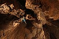
Descent from the "wormhole"

Excentrique in the air passage
Abseiling on "Axel's parking lot"


Web links
Individual evidence
- ↑ a b c Daniel Geil: Steebschacht plan (floor plan). (PDF; 1.36 MB) Blaubeuren Cave Association, July 27, 2020, accessed on July 27, 2020 .
- ↑ Cave Club Blaubeuren eV - Steebschacht to 2010. Accessed February 22, 2019 .
- ↑ Höhlenverein-Blaubeuren eV - Steebschacht 2011-2015. Retrieved February 22, 2019 .
- ↑ Höhlenverein-Blaubeuren eV - Steebschacht 2016-2017. Retrieved February 22, 2019 .
- ↑ Höhlenverein-Blaubeuren eV - Steebschacht 2018-2019. Retrieved February 22, 2019 .
- ↑ Steebschacht telemetry. Höhlenverein Blaubeuren eV, October 15, 2019, accessed on October 21, 2019 .