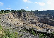
Donnerkuhle quarry
The Donnerkuhle quarry is located in Hagen near Hohenlimburger Strasse ( Bundesstrasse 7 ). In it is dolomitic limestone mined. The operator is the Rheinkalk company ( Lhoist Group ).
geology
Dolomitic limestone has been mined in the Donnerkuhle quarry since the beginning of the 20th century. The area of the quarry is around 67 hectares . Its deepening was approved in 2011 up to a level of +42 m above sea level. The Donnerkuhle is a raw material deposit that is unique in Germany and is located on the northern edge of a mass limestone occurrence of the rivers Volme and Lenne (mass limestone of the Emster plateau) up to 600 meters thick, which was formed about 370 million years ago in the higher Middle Devonian. The reef limestone usually does not show any stratification (hence the name "mass limestone") and is usually very pure. It usually consists of more than 95% of the mineral calcite. In the Donnerkuhle area, however, this pure limestone was partially converted into dolomite stone by the addition of magnesium-containing water.
East of the quarry, the Temporary Mastberg nature reserve with the landscape plan of the city of Hagen was designated by the city council of Hagen in 1994 . This area of the Mastberg was only temporarily (temporarily) designated because it was planned to have this area of the mountain mined by the quarry adjoining to the west. The NSG determination ceases to apply when a rock mining permit becomes legally binding under the Federal Immission Control Act.
See also
Web links
Individual evidence
- ↑ https://geopark.metropoleruhr.de/geopark-ruhrgebiet/geopark-entdecke/geotope/hagen-donnerkuhle.html
- ↑ Martin Schlüpmann: Refractories versus nature - dolomite quarry in Hagen is to be expanded. Nature conservation in NRW 17th year, 1/2006, pp. 6-8.
- ^ City of Hagen: Landscape plan of the city of Hagen . Hagen 1994, p. 212.
Coordinates: 51 ° 21 ′ 46.4 " N , 7 ° 31 ′ 42.2" E


