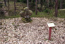
Stone cross near Ungerthal
The stone cross near Ungerthal is a historical land monument near Ungerthal , a district of the Central Franconian municipality of Büchenbach in the Roth district in Bavaria . It is also known locally as the driver 's cross.
location
The stone cross is located in the forest about 750 meters southeast of Ungerthal and 900 meters north of Kühedorf . It stands there near a forest road and is station number 14 of the 14 kilometer long legend hiking trail in Heidenberg .
description
The stone cross is not a typical atonement cross that a murderer had to put up, but a memorial to a fatal accident. The squat looking sandstone cross has the shape of a Greek cross and is about 90 cm × 60 cm × 20 cm in size. It stands on a stone base. The left cross arm was broken off and was reattached. The front and back have markings in the intersection area. A drag shoe and grooves are carved on the front and the letters SP are chiseled on the back . The cross used to mark the border to the Schwabacher SP italwald. The stumbling block is a warning to the drivers.
An information board is set up on site:
"Once here on Weißenburger Stieg a carter is said to have forgotten to push the brake shoe under the wheel despite the warning from his co-driver about the sloping, loamy ground - the horses stumbled under the weight of the sliding carriage - his sigh to heaven came too late - he got it under the wheels and was crushed. This stone cross was erected in memory. So the victim now has to sit on the stone cross beam, not visible to anyone, and wait until someone redeems him. "
On historical maps of the 19th century the cross is marked as a cross stone .
Web links
Individual evidence
- ↑ Hiking trails in Heidenberg (PDF) buechenbach.de, accessed on June 30, 2019
- ↑ Location of the stone cross in the Bavaria Atlas , accessed on June 30, 2019
- ↑ Information board on site
- ↑ BayernAtlas first recording (1808–1864) , accessed on June 30, 2019
Coordinates: 49 ° 17 '1.32 " N , 11 ° 1' 10.13" E


