
Kühedorf
|
Kühedorf
Büchenbach municipality
|
|
|---|---|
 |
|
| Height : | 386 (381-405) m above sea level NHN |
| Residents : | 126 (May 25 1987) |
| Postal code : | 91186 |
| Area code : | 09171 |
 Fire station
|
|
Kühedorf is a district of the municipality of Büchenbach in the Central Franconian district of Roth .
geography
The village is 6 km south of Schwabach on the southern slope of the 463 m high Heidenberg . The Aurach , a western tributary of the Rednitz , flows 1.5 km south of the village . About 800 m northeast of Kühedorf in the forest areas "Bergholz" and "Hierlach" there is a former quarry that is now a geotope . These are several historical, strongly overgrown quarries , which are designated by the Bavarian State Office for the Environment as geotope 576A002 (see also list of geotopes in the district of Roth ). Approx. The corridor area "Katzenhöhle" is 0.5 km south.
The district road RH 5 leads via Schopfhof to Götzenreuth (2.3 km west) or to Büchenbach (2.2 km east). A communal road runs to Gauchsdorf (1.4 km southwest).
history
In the 13th century the place probably consisted of 3 whole courtyards. In 1236 there was the first written mention of the place in connection with a "minister de Ku e dorpf" from the Nuremberg line of a family of Staufer Reich ministers (Die Küdorfer ). The place name should have cows as a defining word . There was also a castle, which has been abandoned except for small remains since 1556. At the beginning of the 19th century only “the moat, some buried vaults and the two round towers protruding from the bottom were left (...). About 50 paces away are the ruins of the castle and the burial chapel, where the coats of arms are still visible. ”In addition, there was a late medieval village church in Kühedorf with a surrounding cemetery and nobility burial place, which was parish to St. Jakobus (Abenberg) .
In Urbar for the castle Count's Office Schwabach, which was erected about 1360, the place is called "Ku e mentioned edorff". In the Burggräflichen Salbuch from 1410 1 good, 1 half good, 2 good and 1 half good are given for “Küdorf”. In the Salbuch of the now margravial office of Schwabach, which was set up in 1434, 1 good and 4 Seldengüter were given for the place . In 1530 only 3 estates were margravial, while 3 other estates were owned. In 1732 there were 8 properties in Kühdorf (1 Ganzhof, 1 Halbhof, 6 Gütlein), all of which were subordinate to the caste office in Schwabach, according to the descriptions of the Oberamts by Johann Georg Vetter . Towards the end of the 18th century there were 11 properties in Kühedorf (4 whole courtyards, 1 half courtyard, 4 Köblergüter , 1 estate with tavern , 1 empty house ) and a community shepherd's house . The high court exercised the Brandenburg-Ansbach Oberamt Schwabach . The Schwabach caste office held the village and community rulership as well as the lordship over all properties. In 1801 there were still 11 properties in the village.
As part of the municipal edict, Kühedorf was assigned to the Büchenbach tax district , Section II , in 1808 . It belonged to the rural community of Ottersdorf formed in 1818 . On January 1, 1972, Kühedorf was incorporated into Büchenbach as part of the regional reform in Bavaria .
In Kühedorf there is a legend station on the legend hiking trail . There is also a wildlife park, a forest playground, two Franconian country inns and a parking lot for hikers.
Architectural monuments
- Schloßstraße 3: two-storey farmhouse in sandstone cuboid construction with storey and gable-articulated profiles from the middle of the 19th century, ancillary building around 1890 with an associated large knight's tombstone from the 15th century
- Schloßstraße 4: ground floor farmhouse in sandstone cuboid construction with broken pitched roof, re. 1889; Sandstone ashlar barn with a broken pitched roof was remodeled in 1929
- Church or chapel with cemetery from the Middle Ages and a castle stables (D-5-6732-0011, gone)
The historic stone cross near Ungerthal is located north of Kühedorf .
Population development
| year | 1818 | 1840 | 1861 | 1871 | 1885 | 1900 | 1925 | 1950 | 1961 | 1970 | 1987 |
|---|---|---|---|---|---|---|---|---|---|---|---|
| Residents | 102 | 115 | 114 | 114 | 101 | 111 | 97 | 114 | 98 | 126 | 126 |
| Houses | 16 | 16 | 22nd | 21st | 20th | 22nd | 19th | 30th | |||
| source |
religion
The place has been predominantly Evangelical-Lutheran since the Reformation. The inhabitants of the Evangelical Lutheran denomination are parish to St. Willibald (Büchenbach) .

Farmhouse in Kühedorf
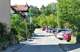
The Ritterstrasse
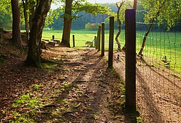
Game reserve
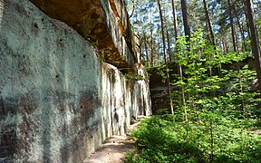
former sandstone quarries on Heidenberg

Inn
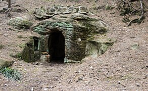
The "Luderloch" on Sagenweg
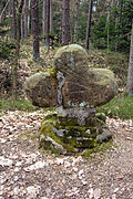
Kreuzstein am Sagenweg


literature
- Johann Kaspar Bundschuh : Kühendorf . In: Geographical Statistical-Topographical Lexicon of Franconia . tape 3 : I-Ne . Verlag der Stettinische Buchhandlung, Ulm 1801, DNB 790364301 , OCLC 833753092 , Sp. 231 ( digitized version ).
- Friedrich Eigler : Schwabach (= Historical Atlas of Bavaria, part of Franconia . I, 28). Michael Laßleben, Kallmünz 1990, ISBN 3-7696-9941-6 , p. 402-403, 478 .
- Gottfried Stieber: Kühedorf . In: Historical and topographical news from the Principality of Brandenburg-Onolzbach . Johann Jacob Enderes, Schwabach 1761, p. 533-536 ( digitized version ).
- Willi Ulsamer (Ed.): 100 Years of the Schwabach District (1862–1962). A home book . Schwabach 1964, DNB 984880232 , p. 400-403 .
Web links
- Kühedorf on the Buechenbach website
- Kühedorf in the location database of the Bavarian State Library Online . Bavarian State Library
- Kühedorf in the Topographia Franconiae of the University of Würzburg , accessed on September 23, 2019.
- Kühedorf in the historical directory of the association for computer genealogy
Individual evidence
- ↑ a b Bavarian State Office for Statistics and Data Processing (Ed.): Official local directory for Bavaria, territorial status: May 25, 1987 . Issue 450 of the articles on Bavaria's statistics. Munich November 1991, DNB 94240937X , p. 347 ( digitized version ).
- ↑ Kühedorf in the Bavaria Atlas
- ↑ F. Eigler, p. 245.
- ↑ a b F. Eigler, p. 226 f.
- ↑ JK Bundschuh, Vol. 3, Col. 231.
- ↑ F. Eigler, p. 402f.
- ↑ JK Bundschuh, vol. 3, col. 231. There is incorrectly mentioned 11 other properties that would be subordinate to foreign owners.
- ↑ F. Eigler, p. 478.
- ↑ Heidenberg hiking map
- ^ Bavarian State Office for Monument Preservation
- ↑ Only inhabited houses are given. In 1818 these were designated as fireplaces , in 1840 as houses , and from 1871 to 1987 as residential buildings.
- ↑ Alphabetical index of all the localities contained in the Rezatkkreis according to its constitution by the newest organization: with indication of a. the tax districts, b. Judicial Districts, c. Rent offices in which they are located, then several other statistical notes . Ansbach 1818, p. 51 ( digitized version ).
- ↑ Eduard Vetter (Ed.): Statistical handbook and address book of Middle Franconia in the Kingdom of Bavaria . Self-published, Ansbach 1846, p. 237 ( digitized version ).
- ^ Joseph Heyberger, Chr. Schmitt, v. Wachter: Topographical-statistical manual of the Kingdom of Bavaria with an alphabetical local dictionary . In: K. Bayer. Statistical Bureau (Ed.): Bavaria. Regional and folklore of the Kingdom of Bavaria . tape 5 . Literary and artistic establishment of the JG Cotta'schen Buchhandlung, Munich 1867, Sp. 1087 , urn : nbn: de: bvb: 12-bsb10374496-4 ( digitized version ).
- ↑ Kgl. Statistical Bureau (ed.): Complete list of localities of the Kingdom of Bavaria. According to districts, administrative districts, court districts and municipalities, including parish, school and post office affiliation ... with an alphabetical general register containing the population according to the results of the census of December 1, 1875 . Adolf Ackermann, Munich 1877, 2nd section (population figures from 1871, cattle figures from 1873), Sp. 1253 , urn : nbn: de: bvb: 12-bsb00052489-4 ( digitized version ).
- ↑ K. Bayer. Statistical Bureau (Ed.): Localities directory of the Kingdom of Bavaria. According to government districts, administrative districts, ... then with an alphabetical register of locations, including the property and the responsible administrative district for each location. LIV. Issue of the contributions to the statistics of the Kingdom of Bavaria. Munich 1888, Section III, Sp. 1188 ( digitized version ).
- ↑ K. Bayer. Statistical Bureau (Ed.): Directory of localities of the Kingdom of Bavaria, with alphabetical register of places . LXV. Issue of the contributions to the statistics of the Kingdom of Bavaria. Munich 1904, Section II, Sp. 1260 ( digitized version ).
- ↑ Bavarian State Statistical Office (ed.): Localities directory for the Free State of Bavaria according to the census of June 16, 1925 and the territorial status of January 1, 1928 . Issue 109 of the articles on Bavaria's statistics. Munich 1928, Section II, Sp. 1298 ( digitized version ).
- ↑ Bavarian State Statistical Office (ed.): Official place directory for Bavaria - edited on the basis of the census of September 13, 1950 . Issue 169 of the articles on Bavaria's statistics. Munich 1952, DNB 453660975 , Section II, Sp. 1126 ( digitized version ).
- ↑ Bavarian State Statistical Office (ed.): Official city directory for Bavaria, territorial status on October 1, 1964 with statistical information from the 1961 census . Issue 260 of the articles on Bavaria's statistics. Munich 1964, DNB 453660959 , Section II, Sp. 825 ( digitized version ).
- ^ Bavarian State Statistical Office (ed.): Official place directory for Bavaria . Issue 335 of the articles on Bavaria's statistics. Munich 1973, DNB 740801384 , p. 179 ( digitized version ).

Asbach | Aurau | Breitenlohe | Büchenbach | Gauchsdorf | Götzenreuth | Hebresmühle | Kühedorf | Neumühle | Ottersdorf | Schopfhof | Tennenlohe | Ungerthal