
Tirschenreuther pond pan
Coordinates: 49 ° 53 ′ 43.4 " N , 12 ° 18 ′ 24.1" E

The pond area in the triangle between the three villages of Tirschenreuth , Mitterteich and Wiesau in the Tirschenreuth district ( Upper Palatinate ) is known as the Tirschenreuth pond pan . Most of the ponds were created in the Middle Ages, the total area at that time was over 2000 hectares.
description
The area around the Tirschenreuther Teichpfanne has often been referred to as the land of a thousand ponds. 3724 ponds and ponds are said to exist in the area of the Tirschenreuth district. That corresponds to an area of 15 square kilometers. In the center of this area there is pond to pond. Most of the time they are only separated from each other by a dam. Often they only have a shallow water depth of one to two meters. Only a few ponds with boggy subsoil and some abandoned clay pits in the Wiesau area are deeper. These reach a depth of 10 to 15 meters.
Most of the ponds are still used for carp farming . Most fish farmers do this on the side and for only a few it is the main livelihood.

Many of these ponds were created on the initiative of the Cistercian monastery Waldsassen . However, only about 160 ponds are said to have been owned by the monastery itself. Most of them were created by farmers, citizens and officials. The ponds owned by the monastery were gradually privatized after the secularization in 1803.
Large parts of this area have now been incorporated into the Waldnaabaue nature conservation project on the basis of the European Fauna-Flora-Habitat guidelines . The area is included in the Tirschenreuth district's fish adventure weeks every year .
The disused Wiesau – Bärnau railway line runs west of Tirschenreuth in the southern area of the Teichpfanne. Today, a 28.4 km long Vizinalbahn cycle path for 5.9 million euros has been laid on its route . In 2012, the 70-meter-long and 20-meter-high Himmelsleiter ( ⊙ ) vantage point was built near the Kühstein pond above the cycle path according to plans by the architect Peter Brückner, Brückner & Brückner office, from which there is a very good view of the pond landscape of the Waldnaabaue. The building is intended to embody the region's will to progress.
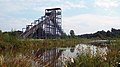
Tirschenreuth heavenly ladder

Evening mood over the ponds
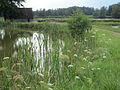
Dams between individual ponds

Tirschenreuth heavenly ladder


The largest ponds
- Paulus sponge
- Seidlersreuther Weiher
- Kornthan pond
- Rothenbürger Weiher
- Rollnhofer Weiher
The two city ponds of Tirschenreuth, which were laid out around 1200 and then drained in 1808, were 90 and 97 hectares respectively, and were many times larger than the existing facilities.
literature
Weng water, v'l fish, from people, fish and ponds in the Stiftland; Edited by Teichgenossenschaft Tirschenreuth, Spintler Druck und Verlag GmbH, Weiden.
Web links
Individual evidence
- ↑ Waldnaabaue with Himmelsleiter on erlebnis-fisch.de