Stoffels (Waltenhofen)
|
Stoffels
Municipality Waltenhofen
Coordinates: 47 ° 38 ′ 0 ″ N , 10 ° 13 ′ 0 ″ E
|
|
|---|---|
| Height : | approx. 900 m |
| Postal code : | 87448 |
| Area code : | 08379 |
Stoffels is a village in the municipality of Waltenhofen near Niedersonthofen in the Oberallgäu district .
geography
Stoffels is located at about 900 meters above sea level directly below the 1067 meter high Stoffelberg. It can only be reached via lenses and via a forest path to Rieggis. In the village, the main European watershed runs over a fen at 978 meters above sea level.
Stoffels is situated in a 524-hectare conservation area around the Stoffelberg.
Attractions
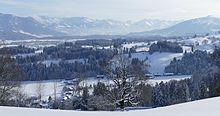
Stoffels is known for the mountain view and the view of the entire Niedersonthofen lake . The Stoffelberg itself offers a wide panoramic view and, in winter, a groomed trail around the mountain and to Rieggis.
economy
In Stoffels there is an alp with a cheese dairy and a lookout bar. The youth hostel is visited by youth groups all year round. Some farms operate grassland.
Footnotes
- ^ Advertisement of the Stoffelberg landscape protection area in the Bavaria Atlas
- ↑ Demeter Alpe Stoffels
- ↑ Berghof Alpenblick Stoffels
- ↑ Jugendberghaus Stoffels

