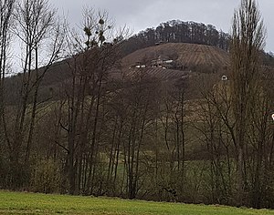
Stollberg (Steigerwald)
| Stollberg (Steigerwald) | ||
|---|---|---|
| height | 476 m above sea level NHN | |
| location | Bavaria | |
| Mountains | Steigerwald | |
| Coordinates | 49 ° 52 '31 " N , 10 ° 25' 43" E | |
|
|
||
The Stollberg is 476 m above sea level. NHN one of the highest mountains in the Steigerwald . It is located in the district of Schweinfurt in Lower Franconia .
Geographical location
The mountain is best known for its exposed location and wine growing. The Stollberg rises on the western edge of the Steigerwald. It is slightly higher than the neighboring mountains and largely separated from them. In addition, it protrudes far into the flatter landscape of the Handthal es, which is 150 meters lower. As a result, the mountain looks very striking, especially from the south side, and offers a very good view. The southern slope of the mountain is completely covered with vineyards. The rest of the mountain is forested. The wine-growing town of Handthal lies at the foot of the mountain.
wine growing
The highest located wine-growing region in Franconia is located on the Stollberg. Traditionally, the first grape harvest usually begins here in autumn.
Attractions
The Stollburg castle ruins are on the summit . From the former castle complex, now a ground monument , a 14 meter high remnant of the octagonal keep with walls up to 2.5 meters thick has been preserved. Smaller wall and vault remains and a half-buried cellar entrance are still preserved from the castle.
See also
Web links
Individual evidence
- ^ Stollburg castle ruins - Franconian tourism association. Retrieved December 26, 2017 .
- ↑ The best hikes to the highlight Stollburg ruins | Komoot. Accessed December 26, 2017 (German).
- ↑ Stollburg Castle ruins - www.burgen.blaue-tomat.de Retrieved December 26, 2017 .

