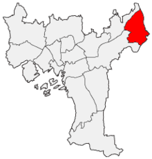
Stovner
Stovner is a northeastern part of the Norwegian capital Oslo . It has 33,316 inhabitants (2020) and an area of 8.2 km².
The district borders in the north on the municipality of Nittedal , in the northeast and east on Skedsmo , in the east on Lørenskog, in the south it borders on the districts of Alna with Ellingsrud and Østmarka . To the west, Stovner borders the Grorud district . Stovner is right next to Gjelleråsmarka , which is a popular forest area in northern Oslo. Lillomarka is also to the west .
The district was a well-known agricultural area in the Middle Ages, the route from Oslo to Romerike and on to Trondheim led through the settlement . In 1777 the forerunner of today's Trondheimsveien was built here. Due to the long tradition as a transit area, there is an old hospitality and accommodation tradition in this district.
The fine grorud granite found along Trondheimsveien became popular as a building material in the 18th century. Numerous stone carvers from Stovner to Årvoll bear witness to this tradition. The tablets of the law in front of the Storting are made of this granite .
Around 1900 the eastern part of the area was parceled out, which is today Alt-Stovner ( Gamle Stovner ) and Høybråten . Høybråten quickly grew into the center of the city. While this part was urban, the other parts of the city continued to be dominated by agriculture.
With the district reform on January 1, 2004, Høybråten became part of Stovner. Høybråten and Stovner, which had been separated since 1973, were thus merged again. During this time Stovner grew by 27,885 inhabitants.
Web links
Individual evidence
- ↑ Follow by bydel, delbydel, grunnkrets, kjønn and alder . Utviklings- og kompanseetaten, Oslo kommune (Norwegian), accessed on April 29, 2020.

