Þykkvabæjarvegur
| Side road 25 Iceland |
||||
| Þykkvabæjarvegur | ||||

|
||||
| map | ||||
| Basic data | ||||
| Operator: | Vegagerðin | |||
| Start of the street: |
Hringvegur ( 63 ° 51 ′ N , 20 ° 24 ′ W ) |
|||
| End of street: | Suður-Nýibær 1 ( 63 ° 44 ′ N , 20 ° 35 ′ W ) |
|||
| Overall length: | 18.55 km | |||
| Development condition: | asphalted | |||
|
Course of the road
|
||||
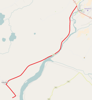
The Þykkvabæjarvegur is a side road in the south of Iceland .
The road 25 is a narrow street, the west of Hella and Ytri-Rangá in southern direction from the ring road branches off and after 16 kilometers from the place Þykkvibær reached. For a further 3 km it leads as a local access road to other farms in the area. The road runs partly on the dams that were built around 1923 to protect against the flooding of the Ytri-Rangá and downstream of the Hólsá .
See also
Individual evidence
- ↑ Vegaskrá 2017 - kaflaskipt. Retrieved January 30, 2018 (Icelandic).
- ↑ Bundið slitlag á þjóðvegum 2019. Retrieved July 23, 2020 (Icelandic).
- ↑ Vegahandbókin , 1973, 2.3
